Indonesia straddles the equator for 3,200 miles. What’s more, it has more islands and covers more longitude than any other equatorial country. It’s a diversely cultural tropical cruising paradise, providing years of non-repetitive location cruising and exploration.
Click image for Indonesia photo gallery
Key cruising area
The region is tropical with wet northerlies from late November to March and drier southeasterlies from April to October. Notably, the 8th Parallel band of islands, including the famous Hindu enclave Bali, is the key cruising area during the SE trade winds and cruisers consider the southern hemisphere winter months.
Year-round destinations
Raja Ampat and all areas in the Equatorial zone are the key cruising areas for what cruisers consider the southern hemisphere summer months. However, cruising around the equator is more based on direct localised weather patterns than seasonality. So cruising yachts, Asian-based superyachts and some private dive charter operators often ply both destinations year-round.
Indonesia’s population is over 275 million with an average age of 29. It’s a fascinating and constantly evolving archipelago nation where ancient traditions and modern technology survive in an uneasy symbiosis. Because of the hundreds of distinct ethnicities and languages, a shared identity has developed around the national motto “Bhinneka Tunggal Ika”. This translates as literally “Many yet one”, meaning a shared unity within the diversity.
Wonderful cruising
The melting pot of Indonesian cultures, amazing surfing, plentiful diving destinations, Komodo dragons and orangutans – and the welcoming local peoples – all make Indonesia a wonderful cruising destination.
Must visit destination
Over 17,500 Indonesian islands and tens of thousands of square miles of pristine oceans and seas make Indonesia a must visit destination. With thousands of anchorages on offer, we have divided the country into five regions, based on what we consider to be the best ports of entry for foreign-flagged yachts.
Five regions
These are 8th Parallel Region, Central Region, Equatorial Region, Sumatra Region and Raja Ampat. Our ports of entry for 8th Parallel Region are Kupang on Timor, coming from Australia, and Batam or Bali en route from Singapore.
For the Central Region use Ambon on the south coast of Ceram. For the Equatorial Region, use Bitung / Manado on the northern tip of Sulawasi and Sorong on Papua. For first arrival to the Sumatra region, Pulau Wei (Sabang) or Batam are the best options. For the Anambas and Neptunas in the South China Sea, best to check in to Batam.
Southeast Asia Pilot author, Bill O’Leary, in Komodo – growing up doesn’t come easy | Photo by APS Indonesia
Clearing into, and cruising in, Indonesia
Procedures for clearing into, and cruising in, Indonesia have vastly improved. Your yacht can be temporarily imported for three years. As 2025 the process is online, starting with the Vessel Declaration (VD). You can start the registration process to apply for the VD here. And at the following link there is a comprehensive VDS user manual. These links were working at the time this page was updated.
Be aware that cruisers have reported waiting up to a month for confirmation of their VDS registration, without which you can’t start making the Vessel Declaration.
The documents that need to be submitted are the same as for the previous cruising permits, namely:
⇒ Yacht’s Certificate of Registration (private yacht) ⇒ Proof of insurance, including wreck removal ⇒ Crew and passenger lists, including passport details ⇒ Port clearance documents from previous port ⇒ Technical details of the yacht and associated vessels (tenders etc) ⇒ Details of the crew’s valuables (eg cameras, smart phones, electronic equipment). ⇒ Declaration that goods such as firearms, explosives etc are carried on board.
Five departments
Five government departments must be visited and sign off on a visiting yacht’s first entry before it is free to embark on its Indonesian cruising adventures. Immigration, Customs, Quarantine, Navy and finally (but certainly not least) the local Harbour Master are involved in facilitating every procedural step.
Visa requirements
The latest reliable information available is that it is mandatory for all yachts visiting Indonesia obtain a cruising permit and all on board to have visitor visas or have passports from countries eligible for Visa On Arrival (VOA). To enter Indonesia all crew passports must be valid for more than six months after the date of entry. Current visa laws have country categories, so please check online or at the nearest Indonesian consulate for your particular country’s visa requirements.
Best way forward
One important rule of thumb to note is that in dealing with any officials in Indonesia, patience and respectfulness are paramount. The larger the vessel, the more patience.
Nevertheless, for larger yachts and vessels, we strongly recommend contacting local agents prior to arrival to assist clearing in, bunkering, provisioning, providing guides and the much sought-after local ‘advice’ – especially for superyachts.
Yacht Agents can play an important role in trouble-free traversing Indonesia given the many cultural and logistical challenges that invariably present themselves.
Yachts without a cruising permit may stay for 48 hours only, in serious emergency, and must remain at the port of entry.
Anchorages in Indonesia
>>> Click herefor a complete list of anchorages in Southeast Asia Pilot. Instagram
This route is the traditional journey from Australia in the east or Singapore to the north. En route are the Komodo Islands, famous for their dragons, and Bali, Hindu island of the Gods.
The sheer distances involved mean there are well over 300 available small yacht anchorages in and around these islands. We list only a few of our own favourites – and welcome new information and vital feedback. Read more...
The central region lies generally between the 3rd and 7th parallels. This region contains the historically significant Spice Islands of the Banda Sea and the lesser-known Kai, Wakatobie and Gorong groups. Further east is central Papua, home of the fantastic Asmat coastal tribes. Read more...
Ternate city with Gunung Api Gamalama in the background | Photo by Ricard Buxo
This massive region from the 3rd parallel south to the 5th parallel north encompasses some of the most fascinating cruising grounds on the planet. Running west from Chandrawassy Bay on north Papua Read more...
A peaceful Anak Krakatau in January 2016 | by Tyke / commons.wikimedia.org
Sumatra is the westernmost of the Sunda Islands and is the largest island entirely Indonesian governed. The larger island, Kalimantan, is shared between Malaysia, Brunei and Indonesia. Sumatra is the world’s sixth largest island with a population of over 50 million. Read more...
A combination of captivating scenery, outstanding diving and exuberant nature has made Raja Ampat an increasingly popular destination amongst cruisers in the past decade Read more...
Note that this website may not reflect the most recent updates to the printed book and the eBook. While every effort has been made to ensure that the information contained in this book is accurate, the charts of anchorages are based on personal experience and satellite imagery and are intended as a guide only. They should not be used for navigation. Please refer to Official Hydrographic Charts of the respective countries.
This website uses cookies to improve your experience. We believe you'll be OK with this, but you can opt-out if you wish. Or you can go to 'cookie settings' and choose which cookies to allow.
Privacy policy
Cookies are small text files that can be used by websites to make a user's experience more efficient. The law states that we can store cookies on your device if they are strictly necessary for the operation of this site. For all other types of cookies we need your permission. This site uses different types of cookies. Some cookies are placed by third party services that appear on our pages.
Necessary cookies help make a website usable by enabling basic functions like page navigation and access to secure areas of the website. The website cannot function properly without these cookies.
Marketing cookies are used to track visitors across websites. The intention is to display ads that are relevant and engaging for the individual user and thereby more valuable for publishers and third party advertisers.
Preference cookies enable a website to remember information that changes the way the website behaves or looks, like your preferred language or the region that you are in.


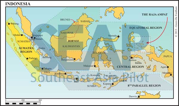


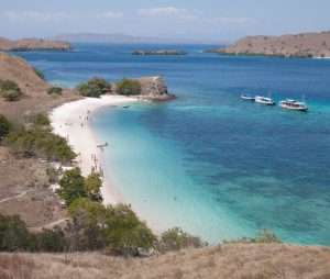 Photo by Maxontravel/shutterstock.com
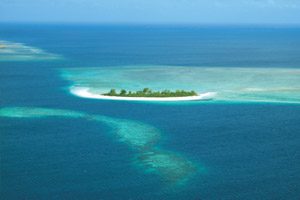 Photo by Bill O’Leary
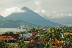 Ternate city with Gunung Api Gamalama in the background | Photo by Ricard Buxo
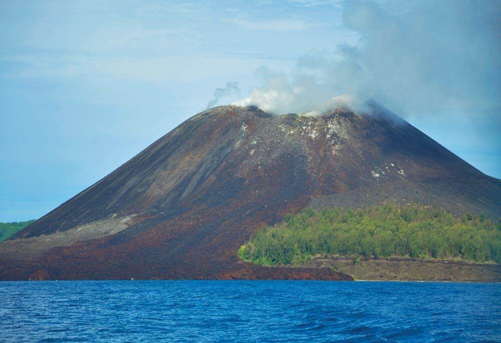 A peaceful Anak Krakatau in January 2016 | by Tyke / commons.wikimedia.org
 Photo by Ricard Buxo