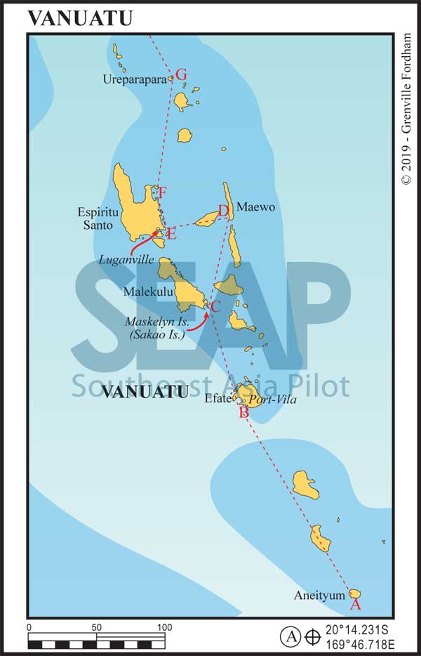
Formerly the Anglo-French ‘condominium’ New Hebrides, Vanuatu gained independence in 1980. The country comprises 13 main and many smaller islands, stretching 650 kilometres from north to south. The capital is Port-Vila on the island of Éfaté.
Vanuatu’s population, called ni-Vanuatu (often shortened to ‘Nivan’), is mostly Melanesian. While the majority live in the countryside working the land, there has been a move since independence to the urban centres of Port-Vila and Luganville. The official national language is Bislama, but there more than 100 Melanesian dialects in use; French and English are also accorded ‘official language’ status.
elatively unspoiled outside the main centres, sub-triopical Vanuatu’s unspoiled islands await the adventurous cruiser.

>>> Click here for a complete list of anchorages in Southeast Asia Pilot.
325 miles from Luganville


The southernmost island in the Vanuatu archipelago, this is an excellent first stop if you’re coming from Cairns (or New Zealand).
Clearing in with customs and immigration is possible but most likely there won’t be any officers present unless you make prior arrangements. In most cases, if you email the head offices in Efate ahead of time they’ll allow you to stop.
Another option is make your way into the anchorage and fly the quarantine flag. The locals are generally curious and they’ll come to you in canoes bearing coconuts and other local produce.
Anchor in 11-14 metres. Mystery Island has a dock, where cruise ships offload passengers, and a small airstrip. Make sure you ask the chief if you can use the beach or island before you go.
160 miles from Luganville


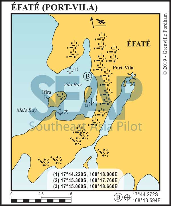
The capital city of Vanuatu is Port Vila. A popular port with several good anchorages and excellent provisioning. A wide, clearly marked, channel and range marks the harbour entrance.
Port-Vila is one of two ports in Vanuatu where you can clear in and out and be issued a cruising permit. There are several agents that can help you with this for a reasonable fee; they can be found online.

If you have the time and patience the Nivan officials are very pleasant to deal with. Just be aware that island time is the norm and being rude will get you nowhere slowly! If you do decide to clear in yourself, have printed copies of all email correspondence with customs and immigration. Especially your 48-hour notice of arrival. For vessels without email capabilities the officials are usually understanding if 48 hours turns out to be 72, as long as you have a copy of your original email.
The main anchorage for vessels under 50m is right next to a quarantine buoy and has good holding in 11m metres. There is a small tender dock operated by the dive shop directly onshore. Anchorage (1) is better for larger vessels; anchor in 20-30 metres. In a strong westerly, anchorages (2) and (3) offer better protection. At anchorage (2) the bottom comes up quickly; anchor in 18 metres and never use it in a strong easterly.
The main wharf is in the southern part of the bay just before the channel entrance to Paray Bay. This is where customs are and where you’ll be issued a cruising permit. For large yachts this is the best place to take on fuel and water. Space is limited and reserved for ships, so book in advance.
There are several other docks in the harbour in various states of use. Always inspect the dock with your tender or confirm with the dock’s owner if it’s usable.
Anchorage (3) is in Paray Bay and is 40m+ deep; However moorings are available. For a mooring, hail on channel 16. If no one answers just grab one; they will eventually find you. The best way to enter the bay is from the south. Sail directly towards the main wharf; the clearly marked channel will be to the east. STAY in the channel which is dredged to 15m.
On the northern side of Éfaté, Havana Bay was used as an anchorage for the US navy during WWII. There are three recommended anchorages here: 17°32.940S, 168°16.920E | 17°33.840S, 168°16.380E | 17°36.240S, 168°14.580E.
If you dive in Havana Bay, you’ll most likely find Coca Cola bottles tossed overboard by US sailors. The entrance of the bay is long and deep with good water right up to the beach. In all three anchorages, anchor in 10 metres. Good holding in mud. There’s a great restaurant and small resorts on both sides of the bay.
70 miles from Luganville


The Maskelyns are a small island group on the southeast corner of Malekulu. Enter from the east, just south of Sakao Is. The channel is clearly marked by dark blue water outlined by brown brackish water to south from the tidal flats and mangroves.
At the top of west tip of Sakao Island. there’s point of land just north of the village on the beach. Anchor in 20 metres with good holding in mud.
There are several chiefs that rule each of the islands. The Sakao Is. chief is Chief John. If Chief Jerry knocks on your boat he’ll ask for an exorbitant amount of money to grant you permission to snorkel and use his beaches. $5.00 per head is pretty standard. However, tell him that you’ve already made a deal with Chief John.
Lots of great beaches. Good snorkelling and diving.
58 miles from Luganville


One of the most interesting anchorages in Vanuatu. Stay a quarter mile off the southwest corner of the island if approaching from the south. Come to Lat 15°22.536S and head due east. When you’re in the centre of the bay, head SSE until you’re in 30m of water; holding is good. All the charts I’ve seen are inaccurate. Be extremely cautious entering this anchorage. Without local knowledge don’t attempt it in the dark.
The locals are very friendly and the village is lovely. Make sure you visit the ‘Yacht Club’ where the locals will put on a show called a ‘Custom Dance’ if you ask them.
Spectacular waterfalls, bathing pools, beaches, snorkelling and diving here. In Ansanvari, the chief will often accept school supplies in lieu of, or in addition to, payment for services. If you’re thinking of trying Kava, this is the best place to do that too. (Best check up on the possible side effects. Note Kava is banned in Europe and Canada.)


This is the largest island in Vanuatu and the second place to clear in or out of the country and be issued a cruising permit. If you clear out of Luganville, as long as you provide an itinerary, the officials are very reasonable and will generally give you permission to visit the anchorages and islands north of Luganville.
If wreck diving is your passion, right in Luganville harbour is the SS President Coolidge, a cruise liner converted to a troop and supply ship that sank here during WWII. It’s still full of vehicles and equipment. Lucky for you all the mines that guarded the harbour and sank the Coolidge have been removed.
The harbour is clearly marked and the anchorage is well laid out with good holding. There are several docks to tender in, but all of them are challenging. Anchor in 11 metres with good holding in mud. The harbour is full of debris from WWII, so have a hacksaw and bolt cutters available in case you foul your anchor.
About 10 miles east and north of Luganville, is Palikulo Bay at 15°29.406S, 167°14.751E.
Anchor in 7 metres in fair conditions and never in a strong northerly. Holding is poor on a hard bottom. Several wrecks outline the shore dating back to WWII and in August migrating Humpback whales use this bay as a nursery for their young. There’s a fine beach at the southern end of the bay with a taxi service into Luganville.
36 miles from Luganville


Usually a cruiser’s final stop before heading north to the Solomon Islands. It got its name for obvious reasons: champagne coloured sand with wild hogs in the bush. A lovely anchorage with good snorkelling and diving. Great beach.
Anchor in 20 metres in fair holding in sand and coral.
140 miles from Luganville


One of the outer islands of Vanuatu is Ureparapara, an extinct volcano with the northeast facing wall of the caldera that collapsed eons ago.
Easy approach. Head straight in until you’re at the bottom. Drop anchor in 15-20 metres. Excellent holding in mud.
This is a malaria island so avoid being on land at dusk and dawn.
