


This website uses cookies to improve your experience. We believe you'll be OK with this, but you can opt-out if you wish. Or you can go to 'cookie settings' and choose which cookies to allow. Privacy policy


This massive region from the 3rd parallel south to the 5th parallel north encompasses some of the most fascinating cruising grounds on offer in Indonesia if not the world.
Running west from Chandrawih Bay on north Papua, the Indonesian equatorial region includes the incredible Raja Ampat group, the stark island of Halmahera and northern Sulawasi.
As with all equatorial regions, the weather is hot and mostly wet with some dry calm and windless doldrums days in the better cruising months of November to March.
Rule of thumb on the Equator: it’s either raining or it’s about to rain…
>>> Click here for a complete list of anchorages in Southeast Asia Pilot.
1,070 miles from Bitung


Jayapura is West Papua Regency’s largest city, original capital and by far its busiest seaport. There are a lot of floating hazards and Fish Attracting Devices (FADs) on entry and inside the harbour, so best approach in daylight. Keep in the marked channel north of Pulau Entsjau to motor past the starboard lateral beacon on the mainland into the protected port anchorage to comfortable depth east of the concrete docks.
Our anchorage ‘A’,Jayapura, is not a recommended place to visit unless you really need to go there, or unless you want to visit the famous tribes of Baliem Valley; Jayapura will give you gateway access to get there.
At the time of writing, heavy central government attention is focused on the Free Papua Movement. As a consequence, Jayapura has a strong military presence and visitors can sometimes be scrutinised and vetted to make sure they are not media intending to report on the situation there.
You may find looking for international arrival or departure clearance here attracting a strong official presence.
750 miles from Bitung


Biak is the gateway port to the beautiful Chandrawasih Bay. A wonderful cruising location even though a deep Pacific swell from the northeast can sometimes make it a bit uncomfortable.
Do not rely on navigation beacons or the harbour lights functioning. Approaches to the harbour from the south through the fringing atolls are open and clear but best timed for daylight hours. Follow the leads through the reef opening and run west parallel to the coast for a mile to anchor on the 9-12 metres on sand and broken coral off the small jetty just outside the Instsia Biak Beach.
Full check in facilities are rustic and not much English is spoken. A few local markets have exceptional seafood and the main commercial dock to the west supplies fuel by the drum. There are a few low-end local hotels and restaurants, banks and shops.
The airport is 15 minutes from the harbour with public transport easily accessible. Daily, but inconsistently timed, flights head west to all the main towns or east to Jayapura. Bookings can be difficult because airline computer ticketing systems rarely function.
There is a WWII aircraft wreck dive in 20 metres just outside the barrier reef at 1°11.300S, 136°03.530E and local dive guides are happy to arrange everything at a small fee.
Biak is close to the beautiful and secluded reefs and beaches of the Padaidori islands some 20 miles southeast. These dozen islands are well worth a long visit, especially for diving enthusiasts. Our choice is to shelter inside the Woendi Island lagoon just off the village supply pier in 8-13 metres on sand at 1°15.360S, 136°22.672E. This remote and unspoiled fishing village is truly special and it’s easy to catch the daily supply boat back to Biak to restock supplies.
470 miles from Bitung

Sorong is the main commercial port for this area and is the recognized direct International CIQ entry Port for Raja Ampat cruising. It is a busy, yet easy to enter harbour; the approaches from the north or the west are well buoyed and marked.
Larger boats can anchor in 25-30 metres adjacent to the many live-aboard dive boats east of Pulau Doom and west of the fish factory. Smaller vessels can anchor either closer to Pulau Doom or at our spot closer to the busy dive dock of Ushamina in 14-20 metres on sand.
Sorong is home to myriad local Phinisi live-aboard dive boats, so access to all level of amenities, fuel, water and moderate provisions are easily available. A visit to the local wet market is a must for fresh seafood and in particular mud crab.
The anchorage is approximately 30 minutes from the airport and there are multiple daily flights to all parts of the country. Public transport is everywhere and easily obtained.
Click to view Indonesia photo gallery.

140 miles from Bitung

Anchor on the 15- 23 metre patch anywhere close to the jetties north of the main wharves.
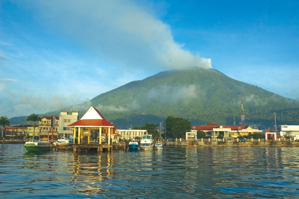
Ternate’s landscape is consumed by the volcanic cone of Gunung Api Gamalama. The sprawling town sweeps to the base of the volcano on the eastern side and is the regional gateway for the entire Halmahere region. Ashore you can find minimum supplies, restricted banking services and a few small local hotels and restaurants. The town is 30 minutes from the airport and there are daily flights to Manado.
From his house in Ternate in 1858, Alfred Wallace wrote the crucial letter to Charles Darwin in England, outlining his theory of evolution. In this groundbreaking ‘Ternate Essay’, entitled “On the tendency of varieties to depart indefinitely from the original type”, Wallace outlined his version of natural selection as it related to his own theory of evolution.
The Wallace Line is an imaginary boundary running more or less north south between Bali and Lombok and Kalimantan and Sulawesi. It delineates Australiasian and Southeast Asian flora and fauna.
Click to view Indonesia photo gallery.
68 miles from Bitung

One of the most common transition passages to the Raja Ampat from a Manado/ Bitung International entry is the west to east crossing across the Molucca Sea from Sulawesi to Halmahera. Half-way between these two is an island and a few rock outcrops called Palau Gureda. This little island, about as isolated as it gets in the world, is covered with coconut plantations and one small village of friendly and welcoming people. As you can imagine, the diving and snorkelling here is special.
Coming from west, approach the anchorage on a direct easterly course, keeping the island 4 miles off to port. Once you have the village at 90 degrees to port, run to port and head in on a north course unobstructed inshore to a comfortable depth for superyachts at 20 -30 metres and anchor on coarse sand. Shallower draft vessels can poke in closer to find shelter in 7-10 metres on the rubble bank behind the eastern reef off the small village.
If arriving from east, approach on a west course, staying well off the dive reef east nestled inshore in the bay. Once clear of the dive reef run in northwest until in front of the village to a comfortable depth. The area charts clearly and correctly position the dive reef. It is a fabulous dive on the southern reef edge.
Click to view Indonesia photo gallery.

We bracket Bitung and Manado together because Manado is the provincial capital, where the main town and airport are located, whereas Bitung on the opposite (eastern) coast is the main port and anchorage. Public transport is available between the two centres and takes one hour and 15 minutes.
Manado is a well-serviced and friendly place with more than its share of good hotels and restaurants. Directly adjacent is BuNikan Island, famous for its historic milestone efforts at ecosystem preservation and regeneration on its coral reefs. As such, the area remains a very popular diving destination.
Manado has a predominantly Christian population and boasts the only active Jewish synagogue in Indonesia.
360 miles from Ambon

The approach from the south is easier straight up the channel. Coming from the north keep the two islands to port and follow the beacons into this industrial-looking anchorage. Deeper draft vessels can anchor on the 32-metre patch and shallower drafts can tuck in under Saren Kechil on the 10-metre patch.
Shore access is either by dinghy into the little beach to the left of the marine police mooring location or driving all the way south to the Bitung Harbour concrete community pier at 1°26.849S, 125°12.589E, usually crowded with local boats. Fuel, water, ice, banking and some basic provisioning are available ashore. Transport to Manado and the airport is frequent and not expensive.
The Lembeh Straight is world renowned for muck-diving, which is the new name for macro organism hunting on a muddy bottom. The elusive mandarin fish, all the most colourful varieties of nudibranch and the full array of marine invertebrates are on offer here for the dive nerds.