This website uses cookies to improve your experience. We believe you'll be OK with this, but you can opt-out if you wish. Or you can go to 'cookie settings' and choose which cookies to allow. Privacy policy
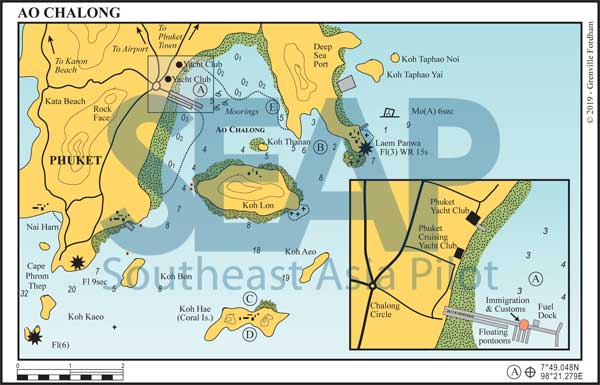
Ao Chalong (Chalong Bay) is the only year-round anchorage at the southern end of Phuket. It is a big shallow bay facing south, protected by the large island of Koh Lon at its entrance.
Only 10 km from Phuket Town by road, this is traditionally the first port of call for visiting yachts. Shoreside you’ll find many restaurants, bars and marine service outlets.

The one-stop port control centre is at the seaward end of the main concrete pier. It is currently operational handling check-in procedures. The ‘local style’ marina is operational and dinghy access is possible.
Currently, best information is to anchor in the bay and head for the pier. The two-storey pink building there houses the immigration office. Complete your check-in there before proceeding to other locations, including marinas. Local regulations now require AIS Class B transponders installed on all yachts.
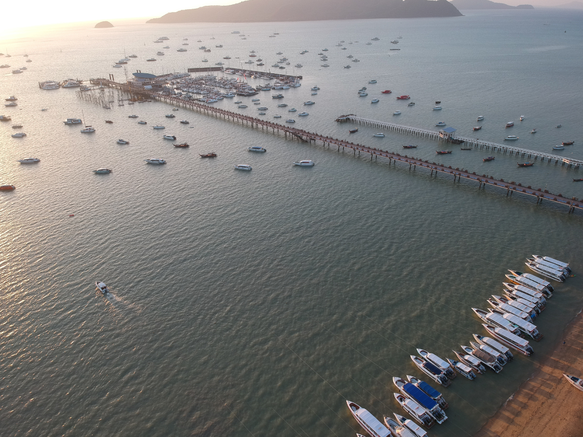
The long government pier gives access to the west side of the bay at low water, where you can find a pontoon to secure your dinghy.
The floating steel pier head allows larger vessels to come alongside. There is a fee (at date of publicaton) of 200 baht per yacht visit to access the jetty.
Diesel fuel is available near the pier head and there is a floating water barge SSW of the pier head. Large areas of sticky mud dry on low spring tides, making dinghy access to the beach impossible.

From the south, care should be taken to stay closer to Koh Lon on your starboard side than to the mainland because here both the bank and the reef extend farther than the Admiralty and Thai charts suggest. At the same time, keep clear of the submerged rocks off the northwest tip of Koh Lon. Just south of the pier there is a shallow sandbank, so motor until east of the pier to find the best anchorage.
From the east, head approximately 285°, leaving Koh Thanan to port. From there proceed past the safe water mark and then between the fixed tripod channel marks towards the Big Buddha on the hill. Avoid the shallow bank in the north of the bay to anchor amongst the other yachts.
Yachts unfamiliar with the anchorage should proceed with caution, especially in the areas immediately north or south of the pier − including the marina entrance.
All the government-laid mooring buoys have broken free, leaving large, unmarked concrete blocks — in some cases close to the surface at low tides. In addition, there are several wrecks sunk in the different areas of the anchorage, some visible at low tide, some not.
Note, however, that as this edition goes to print, there are no public moorings in the anchorage. All moorings belong to resident yachts.
Click to view Phang Nga Bay photo gallery.
FacebookLinkedInInstagram


At Ao Chalong, anchor on the muddy bottom in 3-7 metres well offshore. Preferably well beyond the end of the 800-metre-long concrete jetty, or to the north of it, as it is used daily by express ferries, day trip catamarans and dive boats of all shapes, sizes and speeds. Holding is excellent and the most likely hazard is other boats with inadequate ground tackle dragging into you in a strong wind.
Alternatively, moorings may be arranged for a fee. Check with Capt. Brent at the Phuket Cruising Yacht Club (PCYC) for details of cost, location and safety of the moorings.
In the southwest monsoon season, this is one of the few perfectly protected anchorages on the island (although some ground swell may be experienced). In the northeast season, on the other hand, conditions can be a little choppy because of the long fetch in the bay and this can make dinghy transfers to the beach uncomfortable. There are about 10 days per month when, due to the tide, dinghy access to the beach is impossible for a few hours.
The Phuket Yacht Club (formerly Ao Chalong Yacht Club) is found on the beach half a mile to the north of the jetty at 7°49.634N, 98°20.885E. There’s a floating dinghy jetty in front of the club giving slightly longer access. Best to check with the club if it’s OK to tie your dinghy up to the jetty. The club holds occasional races and/or rallies for keelboats and multihulls and visitors are welcome. There is youth sailing and instruction available.
The club has a bar and restaurant overlooking the bay. Monthly memberships are available for visiting yachts.
Close to the main jetty is a decorative lighthouse that was once a favourite yachty restaurant called ‘The Lighthouse’. At the time of writing, it has been resurrected as Chalong Lighthouse & Lightweed. On the corner by the boat ramp is The Corner Food & Drink. A short walk north, behind the Arch39 hotel, is the Phuket Cruising Yacht Club (PCYC). Both are favourite hangouts for local and cruising yachties and are the source of information on all matters nautical. Both serve food and drinks at low prices. Many other restaurants and bars, both along the beach road and inland up the two roads heading west, also cater to the yachting crowd, a fact reflected in their price structure.
Take either of these roads to the Chalong Circle, a five-way round-a-bout and a bustling commercial centre. An underpass was completed in 2019 running north-south under the 5-way roundabout. From here, roads lead to Rawai, Nai Harn, Kata, Phuket City and the main highway to the airport and the north of the island. On the way you’ll pass an ever-increasing number of out-of-town shopping centres.
Click to view Thailand photo gallery.
FacebookLinkedInInstagram


 On the west side of Cape Panwa is a concrete jetty serving as a base for the Hydrographic, Fisheries and Marine Biological Departments.
On shore you’ll find the Phuket Aquarium. Anchor anywhere in the bay in 6-8 metres on a muddy bottom keeping well clear of the floating pearl farm on the west side. When rounding the cape, use the light on the rock and the safe water mark to keep well clear of the off-lying rocks and reefs.
To the northwest lies Ao Yon. This bay offers moderately good shelter in both seasons and a fine beach. Some cruising yachts and charter operators make this bay their base. Enter from the east side of the bay to anchor in 4-6 metres inside the line of the fish farms on a muddy bottom.
Click to view Thailand photo gallery.
FacebookLinkedInInstagram


On the north coast of Koh Hae there are two sandy bays, still with live coral fringing the beaches. In the southwest monsoon season, sheltered anchorage is available on a sandy bottom in 8-10 metres.
Beware coral heads on the fringe of the reef rising from depths of up to 6 metres. Ashore restaurants cater to hordes of day visitors, with many tour operators bringing their customers for snorkelling. In recent years this anchorage has become a bit of a zoo from 10.00 to 17.00.
Both bays are busy with tourist day trippers, but the easternmost (Banana Beach) is usually more frantic with a combination of speed boats and heavily loaded sailing catamarans.


For a lunchtime stopover, try the small bay in about 14 metres on a rocky bottom on the south side of Koh Hae. This is a very pleasant anchorage – coral and lots of fish. A small sandy beach is accessible at high tide. The local restaurant that used to open during NE monsoon has closed permanently although the dilapidated structure remains. There are a few resident hornbills for the nature photographer.
This bay can get a little crowded with spillover from the northern bays; if it is, head towards the small cove to the west and anchor in 16 metres on a sandy bottom.


In the northeast season, Panwa Bali is more protected from the chop than the main anchorage directly across Chalong Bay. In the southwest season, the anchorage is open to a long fetch across the width of the bay.
Ashore are private housing developments, resorts and restaurants. Just behind the beach is a road that runs to the top of the mountain to a spectacular viewpoint giving a 360-degree panorama (on a clear day) of Phi Phi islands and the south end of Phuket. The trip to Phuket town takes about 30 minutes; finding transport can be difficult so best to download the Grab or Bolt app and ‘call’ one of their cars.
A drying coral reef fringes the sandy beach, but there is an access channel at low tide. Two miles further north in Chalong Bay is a mangrove creek, which can be accessed by dinghy from mid-tide, leading to a picturesque seafood restaurant on stilts.
