45 miles from Terengganu


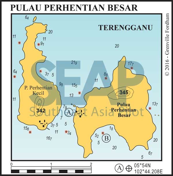
This pair of islands is the last shelter with provisioning opportunity before crossing the Thai border. Rounding the point of Pulau Perhantian Besar to enter the protected channel from the south, what may have appeared to be a relatively uninhabited island is actually full of bungalows, hotels and restaurants on both sides of the channel.

It is easy to anchor virtually anywhere in the channel in 5-8 metres, looking out for the occasional isolated shallow coral patches closer in on the east side. Our spot, in the south at the narrowest part of the channel, is offshore from several rustic dive bungalow resorts with plenty on offer day and night.
Read moreThe group’s administrative centre is the village on Pulau Perhantian Kecil, where limited provisions are available and daily ferries run to Kota Bharu and Kuala Besut from the commercial jetty. Anchorage is available just south of the jetty on sand in 4-7 metres at 5°53.688N, 102°43.767E. The all tide beach south of the jetty is a safe place to leave your dinghy and the local market is a few hundred metres away. Jerry can amounts of fuel are available for sale.
An excellent sheltered spot in the southerly season is around Genting Point to the all-tide beach bay of Perhentian Island Resort. Anchor on sand in 5-8 metres in the middle of the bay at 5°54.248N, 102°44.504E and access the floating jetty in the west of the bay. Alternatively, across the channel at Long Beach is another spot with plenty of bungalow restaurants and dive shops at 5°55.039N, 102°43.436E. Anchor in front of the Mowhin Chalets in the south corner in 4-7 metres on sand.
Out of the channel and a few miles northwest are the twin islets of Susu Dara and the famous dive site Tokong Laut. Moor or anchor just south of the low-lying rocks to dive the underwater caves housing dozens of protected sleeping grey bamboo sharks. Pick up a mooring or anchor in a comfortable depth on sand in the south of the small channel between the rocky island and Pulau Susu Dara Kecil at 5°57.589N, 102°40.844E for access to these iconic dive sites.
Note that this website may not reflect the most recent updates to the printed book and the eBook. While every effort has been made to ensure that the information contained in this book is accurate, the charts of anchorages are based on personal experience and satellite imagery and are intended as a guide only. They should not be used for navigation. Please refer to Official Hydrographic Charts of the respective countries.
Copyright.
The copyright holders of all content, in print and digital editions, are: Published book © Phuket Publicity Services Ltd. Part. / Texts © Bill O’Leary & Grenville Fordham / Design, layout & charts © Grenville Fordham / Photography: © as indicated in photo credits. All rights reserved
No part of this publication may be reproduced, stored, or transmitted in any form or by any means - graphic, electronic or mechanical, including photocopying, recording or otherwise – without the express permission of the publisher, Phuket Publicity Services Limited Partnership, and the other copyright owners.


This website uses cookies to improve your experience. We believe you'll be OK with this, but you can opt-out if you wish. Or you can go to 'cookie settings' and choose which cookies to allow. Privacy policy
