
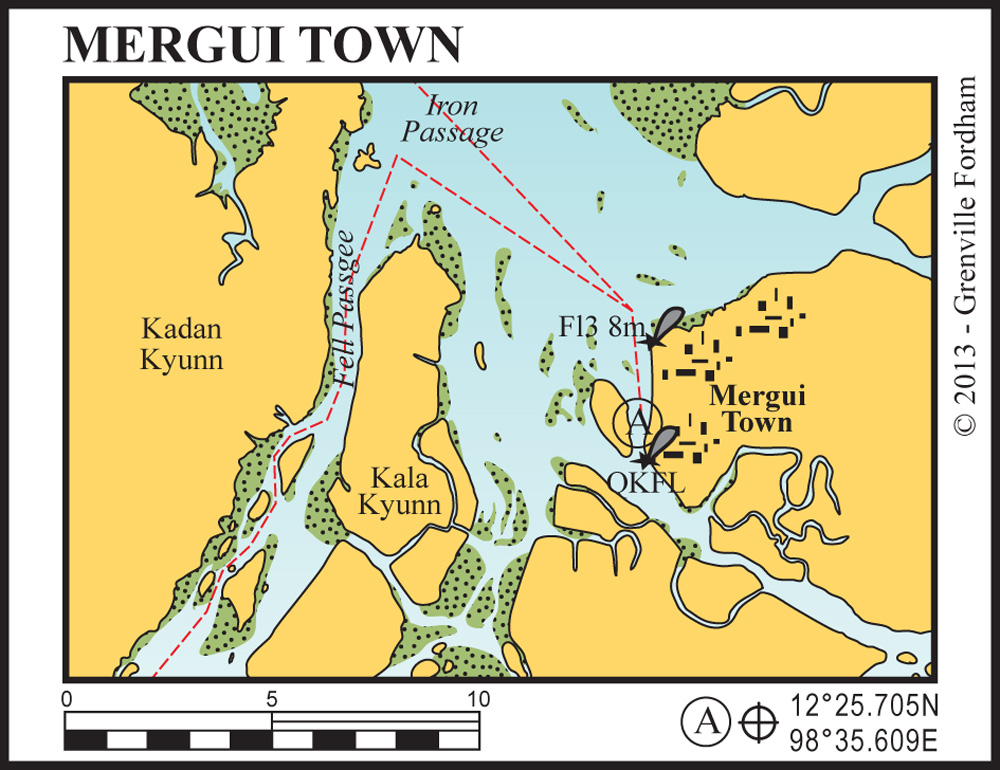
Approach from north through the Iron Passage between Thamihla Kyunn and Kadan Kyunn (King Island). There is plenty of water through the passage although there can be strong currents.
Travelling south after navigating the passage is straight forward until you come to the lighthouse (Fl.8M) at the northern approaches to Mergui Port. The light is a significant structure and can be seen quite clearly.
Pass to the west of the light within 100-150 metres. The waters are shallow during the approach and there are mud flats that dry at low tide further to the west of the light. This area is known as the Mergui Bar.
The port is visible at this point and further south in town is another quick flashing navigational light which may be more difficult to see. The depth of water will remain constant until reaching the anchored vessels in front of the town.
The best anchorage is to be found slightly south of the town directly in front of the large reclining Buddha image on Pataw Island. Depth of water is approximately 15 metres and the holding is good but strong currents prevail. Boat traffic is a little less hectic here.
The shorter route to Mergui Port for shallow draft vessels is the Fell Passage which saves about 25 miles. The depth through the passage is never less than three metres in the centre of the channel.
The navigation is straightforward, although by looking at the chart it does seem daunting. This route is not advisable at spring low tides.
There are three floating pontoons that provide shore access. The middle of the three should be used. It is safe to leave tenders tied to the inner-side of the pontoon.
You need to check in at the port offices, as well as at customs, the harbourmaster and immigration, which are located at the entrance to the floating pontoons, before proceeding into the town.
Mergui is a fascinating town with a colourful history. Established around 1500, its strategic position ensured its rapid growth into a major trade entrepot. Sailing ships of the time, faced with the fickle winds, uncharted reefs and pirates of the Malacca Straits to the south, preferred to offload their trade goods in Mergui.
From here the goods were trans-shipped by elephant convoy across the Malaysian Peninsula to the ancient kingdoms of Ayutthaya, Cambodia and southern China.
The invention of the steam driven cargo ship lessened the importance of Mergui and it gracefully declined into the market town it is today.
The importance of Mergui on an historic Indian Ocean trade route can still be clearly seen today. There is an interesting mix of Chinese, Indian, Arabic and Burmese influences.
Take the time to explore the back streets of Mergui: visit the Chinese tea shop, the market bazaar, the temples and the various restaurants to really get a feel for the unique culture of Mergui.


