
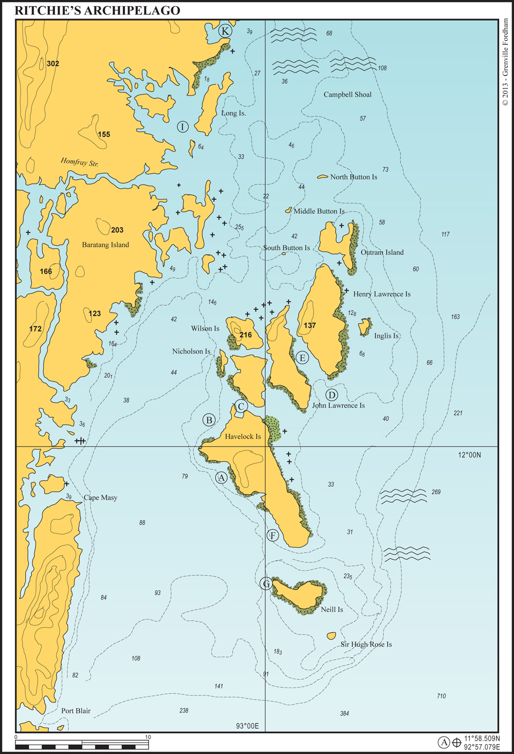
22 miles from Chatham island, Port Blair


No 7 beach is seven miles of white sand backed by tropical forest. Anchor safely anywhere along this beach in 8-12 metres. Ashore there are several resorts, restaurants and access to the main village of Havelock by road. This beach is prone to swell during March and April – be aware what looks like a flat ocean can suddenly throw up a large wave while going ashore by dingy.
27 miles from Port Blair
This is a favoured washing spot for retired logging elephants. Anchor in 12-15 metres away from the coral heads. This anchorage has good snorkelling but is prone to swell during January and February when the northeast monsoon is blowing strongly.
There is now a small water sports center in this bay with some annoying jetskis.
27 miles from Port Blair


This anchorage is the main point of entry to Havelock Island with daily ferries arriving from Port Blair and other islands. There is also a daily seaplane service from here to Port Blair.
The village has a friendly atmosphere with a variety of stores selling fresh goods and general supplies. Land your tender on the beach to the west of the jetty. There are a couple of suitable places to anchor on either side of the marked channel.
On approach, call Havelock Port Control on Ch.16. The approach to this anchorage is well marked and lit. When approaching from the east, watch the northern point of Havelock, as the reef extends further than expected.
On the southern point of Peel Island, opposite the jetty, there is good holding on a sandy bottom in 8-12 metres. This is away from the jetty and the noise of approaching vessels, but is prone to mosquitoes.
With a small yacht you can anchor among the fishing boats immediately to the west of the jetty in 6-8 metres on a sandy bottom, but space is tight inside the reef. Otherwise anchor in 10 metres in the mangrove fringed bay to the west of the lighthouse and use your dingy for the short trip to Havelock jetty.
To the east of Havelock are many reefs and ledges with great diving. Minerva Ledge is extensive with many dive sites but strong currents. It has a mooring buoy at 12°3.899N, 12° 3.899N, which should be used in preference to anchoring on this coral bank.
3 miles from Laccam Harbour
Anchor in 12-18 metres on the east side of the southern point of the island on the sandy bottom; watch out for the edge of the reef.
There is good snorkelling, diving and fishing along the reef edge. While the extended reef offers some protection, if the swell rolls in from the northeast, it is better to move north to anchorage (E).
On the shore to the north are the wrecks of HMS Briton and HMS Runnymede, both of which remarkably ran aground here in the early hours of 12th November 1844.
5 miles from Laccam Harbour
The west side of Henry Lawrence Island provides a well protected anchorage in strong northeasterlies. Kwangtung Strait is entirely navigable with a deep water channel throughout. Anchor in 15-20 metres on a sandy bottom anywhere along the eastern side of the straight. Good holding and very well protected. Strong currents.
The fringing mangroves are interesting to explore by dinghy or kayak with many crabs, monitor lizards, sea eagles and the occasional dugong. The northern side of the strait in the narrows has an interesting drift dive but visibility is poor.
19 miles from Port Blair
Beautiful anchorage away from the villages on Havelock. Anchor in 12-15 metres clear of the reef edge. Great fishing along the reef edge to the southern point. Good snorkelling.
17 miles from Port Blair
Well protected anchorage off the white beach that stretches around Neill to the north. There is good snorkelling to the south along the reef edge. The reef to the south of this anchorage extends much further to the west of Neill Island than is charted. Ashore, along the northern facing coast, there is a small backpacker resort and restaurant.


