SEAP Southeast Asia Pilot-1
  >   Thailand   >   Pattaya & The Eastern Gulf

Koh Chang & Koh Kut island groups

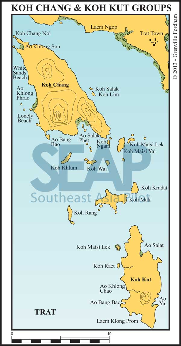
Koh Chang & Koh Kut island groups chart

KOH CHANG ARCHIPELAGO

Koh Chang National Park

A group of more than 50 islands near the Cambodian border, Koh Chang National Park is about 200 miles from Bangkok. It’s famous for beautiful coral, waterfalls and peaceful beaches.

The biggest and northernmost island, Koh Chang (30 x 18 km), is the second largest in Thailand after Phuket and is the most developed of the archipelago. The highest point is Khao Jom Peasat at 744 metres above sea level.

[read more]

The only flat land fringes the ocean on a narrow strip so it is unlikely an airstrip will ever be built, giving it a good chance of escaping the haphazard development of other Thai islands. The waters surrounding the islands have a good variety of hard and soft corals.

The group is bounded to the south by Koh Kut, which is close to the Cambodian border. The nearest city is Trat, served by an airport and highways to Bangkok. This is the capital of Thailand’s most southeastern province, adjoining the Cambodian border. The car ferry to Koh Chang, which operates from 7am to 7pm, leaves the mainland at Tammachat Pier and takes 30 minutes to reach Ao Sapparot.

Koh Chang has long sandy beaches, mostly on the west coast, and is still covered with mountainous rain forest for more than 60 percent of its area.

Koh Mak, the major island between Koh Chang and Koh Kut is covered with coconut groves and has good beaches in its northwest and southwest facing bays. If checking into Thailand here, port and immigration clearance can be done at Leam Ngop pier, while customs clearance is done an hour’s drive away on the road to Cambodia.

[/read]

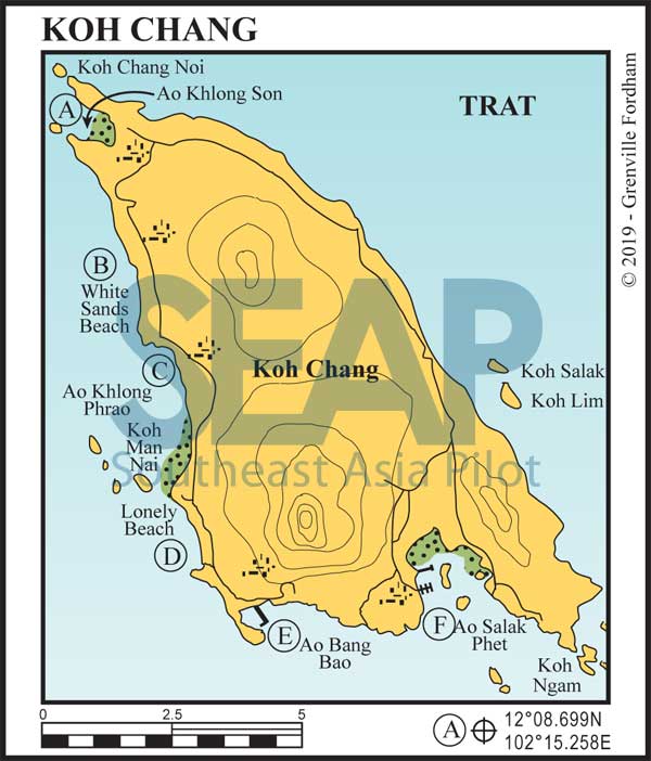
Koh Chang chart
  • A

AO KHLONG SON

101 miles from Ocean Marina

AO KHLONG SON. 12°8.699N, 102°15.258E

Anchor anywhere in the bay in 4-5 metres on a sandy bottom. On the southern headland is the Grand Orchid Resort & Spa. To get into Siam Royal View Marina from the anchorage, head southeast toward the resort, then through the port and starboard channel marks into the small river mouth.

The channel is about 1 metre at LAT so deeper draft vessels should plan the incoming tide. Stay mid-channel for a few hundred metres into the compact 24-berth marina, where average depth is around 3 metres.

Ashore is the Siam Royal View Resort with rooms and F&B facilities. It’s a 10-minute drive from the ferry and the main town on Koh Chang. Call VHF Ch19 or 69 for a local guide to assist you into the creek from the bay.

Click to view Thailand photo gallery.

  • B

WHITE SANDS BEACH

3 miles from Ao Khlong Son

WHITE SANDS BEACH. 12°6.149N, 102°16.004E

A sheltered anchorage in the northeast and tenable in the southwest seasons, anchor in 5-7 metres on sand. The northern end of the beach is an easier dinghy landing as the south end is extremely rocky and dries up to 100 metres at low tide. There is a string of good value beachfront restaurants here and dinghy access is easier as the depth is one metre almost all the way in.

This is the main tourist strip of Koh Chang with restaurants, resorts, supermarkets, banks and beer bars lining the road running just behind the beach.

Click to view Thailand photo gallery.

  • C

AO KHLONG PHRAO

5 miles from Ao Khlong Son

AO KHLONG PHRAO. 12°3.424N, 102°16.885E

This is the flattest and quietest west coast anchorage in the northeast season. Anchor in the northern corner opposite the creek entrance in 5-7 metres. There is a well-stocked supermarket on the road behind the Coconut Resort. The river just south of the anchorage is navigable by dinghy at mid-tide and well worth exploring. There are restaurants and resorts on the inside creek and on the beachfront.

[read more]

Just to the south and north of the shallow tide isthmus to Koh Man Nai is Haad Kae Bai with 20 resorts ashore. Anchor at 12°1.583N, 102°17.121E in 5-6 metres on sand. There’s a small creek with restaurants inside. The Meechai Elephant Camp is ashore in the north of the bay where you can pay a small fee to take a baby elephant for a swim. Not to be missed.

Offshore, but close in here, are Koh Yuak, Koh Pli, Koh Man Nok and Koh Man Nai with reasonable snorkelling off fringing reef. If heading south, leave Koh Man Nai to port.

[/read]

Click to view Thailand photo gallery.

  • D

LONELY BEACH (HAAD THANAM)

9 miles from Ao Khlong Son

LONELY BEACH (HAAD THANAM). 12°0.290N, 102°17.344E

Anchor in 5-7m off the red and white cell towers 300 metres offshore. There’s a half dozen upmarket restaurants and resorts still friendly to visiting yachts, but the backpackers left when the electricity arrived. This is a safe and tranquil overnight anchorage with the odd hippie fire-twirler still dancing on the beach late into the night.

Click to view Thailand photo gallery.

  • E

AO BANG BAO (KOH CHANG)

12 miles from Ao Khlong Son

AO BANG BAO. 11°57.939N, 102°19.004E

Anchor just west of the bustling stilted jetty in 3-5 metres on a muddy bottom near the lighthouse. This spot is sheltered in both seasons and is an interesting mix of local fishing activity, ferries and marine tourism.

The 1-km jetty is lined with an eclectic range of shops and restaurants on a complete range of fare. Head for “Mr T’s” for live music and local curries.

This is the main departure point for tour and dive boats and ferries to the southern islands; it’s a hive of activity. There’s a dinghy dock at Buddha View Restaurant on the pier’s north side. Don’t take your dinghy to the beach because it’s soft sticky mud at low tide.

Click to view Thailand photo gallery.
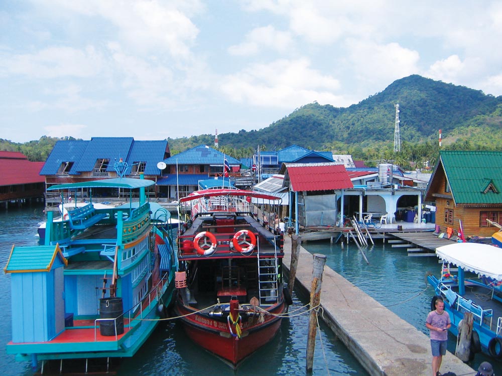
The pier at Bang Bao
The pier at Ao Bang Bao | Photo by Khaosaming/commons.wikimedia.org

Rocks in the water

Beware of the two submerged rocks to the southeast of the western point of Ao Salak Phet. Keep outside the 12 metre contour when navigating between Ao Bang Bao and Ao Salak Phet.

  • F

AO SALAK PHET

15 miles from Ao Khlong Son

AO SALAK PHET. 11°58.706N, 102°22.828E

This is the largest and most sheltered bay on the island and is divided by two smaller islands. It is generally shallow although anchorage is available in the west of the bay in 3-4 metres for good all-year round protection.

[read more]

On the west coast of the bay are three small marinas with a few pontoons based on or at the head of single jetties. Koh Chang Marina at 11°59.188N, 102°22.410E has about 15 pontoons, whilst a quarter mile southeast at 11°58.981N, 102°22.600 is the floating pontoons base for Island Spirit Yacht Charter at Salak Phet Seafood and Resort. South again a few hundred metres is Bang Rong Than Pier with Sailing Koh Chang’s floating dock for about 6 yachts.

Each place offers onshore accommodation, fuel, Internet, water and laundry services. The village at the head of the bay has adequate shops for provisioning, but for major mechanical repairs it’s easy to rent a motorbike or catch a ferry to the mainland town of Trat.

[/read]

Click to view Thailand photo gallery.

World War II wreck

To the east of Ao Salak Phet, off a long beach, is the site of a naval battle between the French and Thai navies during WW II. The Thai vessel still lies between two yellow buoys marking the location. There are plans to sink a World War II 100-metre tank landing ship ‘HTMS Chang’ in the same location to create an artificial reef.

Further west, offshore at 11°53.692N, 102°15.448E the ‘HTMS Chang’ was scuttled in 2012 in 32 metres depth to create a local site for wreck divers.

See also:

  Go to top

While every effort has been made to ensure that the information contained in this book is accurate, the charts of anchorages are based on personal experience and satellite imagery and are intended as a guide only. They should not be used for navigation. Please refer to Official Hydrographic Charts of the respective countries.

Copyright.
The copyright holders of all content, in print and digital editions, are: Published book © Phuket Publicity Services Ltd. Part. / Texts © Bill O’Leary, Andy Dowden & Grenville Fordham / Design, layout & charts © Grenville Fordham / Photography: © as indicated in photo credits. All rights reserved
No part of this publication may be reproduced, stored, or transmitted in any form or by any means - graphic, electronic or mechanical, including photocopying, recording or otherwise – without the express permission of the publisher, Phuket Publicity Services Limited Partnership, and the other copyright owners.

Phuket Publicity Services Partnership, Ltd.,
Phuket Publicity Services Partnership, Ltd.,19/87 Moo 7,T.Srisunthorn, A. Talang, Phuket 83110 Thailand
Privacy policy