
60 years ago, Pattaya was a sleepy little fishing village. Then came the Vietnam War and the incursion of thousands of young American GIs in search of rest and recreation.
The area grew at such a pace, with both Thai and foreign tourists, that the government promulgated the Pattaya City act in 1978, thereby joining Naklua and Pattaya to form the fifth local government municipality. Thus Pattaya City was born with an ever-increasing influx of visitors and residents from the burgeoning surrounding industrial estates.
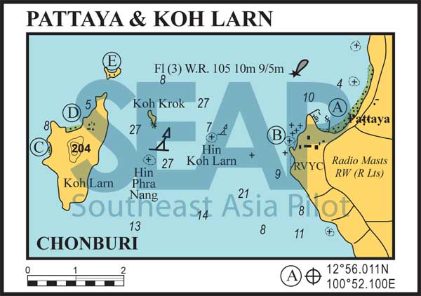
NOTE: On the passage from Koh Larn to Pattaya, avoid the area around Hin Koh Larn, about 1.5 miles east of Koh Krok. Do not rely on the marker buoy, which is frequently washed away or which drags during rough weather. Anchoring at Koh Krok, a private island, is not permitted.
206 miles from ao Nathon, Samui


This anchorage is secure only in the northeast season. Good holding can be found in 4-5 metres a quarter mile north of the gap between Bali Hai Pier and the speedboat marina breakwater. At the time of writing this spot was far enough south to be safe from the dozens of parasailing speedboats running from the many anchored pontoons during the day.
The breakwater running from the south point protects a shallow speedboat marina, but it’s better to dinghy to the beach just east of the Bali Hai Pier. The pier is the main departure point for all kinds of boat activities and high volume island runs.
2 miles from South Pattaya Bay
Anchor only in settled weather and only near the two mooring buoys at the southern end. Stay well clear of the rock awash in the middle of the bay.
This anchorage is not recommended for overnight stays. There is often a shore break, which can upset a small tender and, during the northeast season, the beach can be depleted of sand.
The Royal Varuna Yacht Club house offers good facilities, including a bar, a restaurant and a swimming pool. Visiting yachtsmen are warmly welcomed, but be sure to register with a committee member. Good road links into the city.
7 miles from South Pattaya Bay

This pretty anchorage in 5-8 metres on sand is recommended only as a day stopover – a place for swimming or lunch ashore at the restaurants on Haad Tien. There’s a concrete walkway around the rocks both ends of the beach.
Good snorkelling can be found along the outer edge of the reef that fringes the beach. Further south around the small headland is Samae Beach with dozens of bungalow resorts and restaurants ashore.
6 miles from South Pattaya Bay

Good holding can be found in 5-10 metres on a sandy bottom, lending protection in the southwest season. The sand beach makes for convenient dinghy access to the many hotels and restaurants ashore.
A very popular daytime destination for the tour boats operating out of Pattaya. Numerous speedboats and even a yellow submarine operate from the commercial jetty in the bay.
5 miles from South Pattaya Bay
This small horseshoe-shaped island facing north has a well-sheltered bay in the southerly season. Anchor in about 4-6 metres on a sandy bottom in clear water off the fringing coral reef.
Swim ashore on Koh Sak to a basic seafood restaurant and beach chair vendors. The island used to be an exclusive resort for Thailand’s rich and famous, though it’s now rather rundown. On the footpath leading south from the beach, you’ll see the foot and hand prints of many famous visitors, including Neil Armstrong’s and some old Hollywood legends.


