SEAP Southeast Asia Pilot-1
  >   Indonesia   >   8th Parallel Region

En route to Singapore

Convenient stop over anchorages for any transition passage to or from Singapore are Pulau Bangka and Pulau Belitung. These wonderful scenic little locations are in the middle of the Java Sea between Sumatra and Kalimantan.

Pulau Belitung (Tanjung Pandan)
  • X

PULAU BELITUNG

220 miles from Batavia Marina

PULAU BELITUNG (TANJUNG PANDAN). 2°45.774S, 107°33.337E

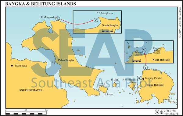
Tanjung Pandan is a designated International CIQ port for checking boats in and out of Indonesia.

It’s a wonderful sheltered little anchorage on the west coast of Belitung. Anchor southeast of the safe water mark in the bay north of Pulau Ularbulu in 15-20 metres in mud and silty sand.

For shore access best take your tender in adjacent to the anchorage and grab a ‘Bemo’ to town. The river and surrounds is very shallow and muddy.

Click to view Indonesia photo gallery.

  • Y

PULAU BELITUNG NORTH

240 miles from Batavia Marina

PULAU BELITUNG NORTH. 2°33.072S, 107°41.273E

This quaint little anchorage is known as Marina Beach. Approach from the north heading to the centre of the bay itself. There are shallower draft anchorages off to starboard from the bay centre, but our recommended anchorage is to port being cautious of an inshore coral shoal. Anchor in 15-20 metres on a sand bottom. Beach access is to the southwest near the local jetty.

Tanjung Tinggi Beach, Pulau Belitung
Tanjung Tinggi Beach, Pulau Belitung | Photo by HeyFromINDO – commons.wikimedia.org

Click to view Indonesia photo gallery.

  • Z

PULAU BANGKA NORTH

310 miles from Batavia Marina

PULAU BANGKA NORTH. 1° 30.101S, 105° 52E

Approach this anchorage from the northwest giving a wide berth of Pulau Mengkudu on port. There are shoals in and around both the island and the cape that are not yet well charted. Once inside the small cape, keeping it to port, ease into 10 metres to anchor on sand. Beach access is largely at high tide as the fringing reef is exposed at low tide.

Click to view Indonesia photo gallery.

See also:

  Go to top

While every effort has been made to ensure that the information contained in this book is accurate, the charts of anchorages are based on personal experience and satellite imagery and are intended as a guide only. They should not be used for navigation. Please refer to Official Hydrographic Charts of the respective countries.

Copyright.
The copyright holders of all content, in print and digital editions, are: Published book © Phuket Publicity Services Ltd. Part. / Texts © Bill O’Leary, Andy Dowden & Grenville Fordham / Design, layout & charts © Grenville Fordham / Photography: © as indicated in photo credits. All rights reserved
No part of this publication may be reproduced, stored, or transmitted in any form or by any means - graphic, electronic or mechanical, including photocopying, recording or otherwise – without the express permission of the publisher, Phuket Publicity Services Limited Partnership, and the other copyright owners.

Phuket Publicity Services Partnership, Ltd.,
Phuket Publicity Services Partnership, Ltd.,19/87 Moo 7,T.Srisunthorn, A. Talang, Phuket 83110 Thailand
Privacy policy