260 miles from Kupang


These two islands are the only natural home of the legendary Komodo Dragons. A must-visit when cruising Indonesia.
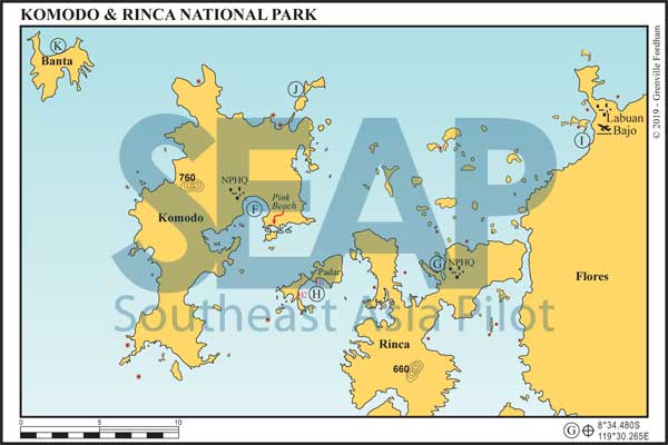
The islands of the Komodo Group are in the middle of the high-current channels between Flores and Sumbawa. Komodo’s south coast is deeply indented with spectacular steep-sided bays. The National Park Head Quarters (Loh Liang) is tucked away in the calm sheltered Sora Lia Bay mid island on the southeast coast. Anchor near the moorings off the two jetties in 10-16 metres on a muddy bottom in front of the Ranger facility.
Onshore, report to the ranger station to buy your mandatory national park entrance permits. Guides are also mandatory and charges are levied for each camera in your group. When planning your walks, the longer you hike, the greater potential for seeing dragons. Always carry drinking water and wear good walking shoes.
There are many bays in this area, some with moorings (anchoring is mostly prohibited and policed) and some where the fishing, snorkelling and diving are pristine and alive with marine activity.
At the southeast point of Sora Lia Bay you will find the world-famous Pink Beach, named because the shoreline consists of crushed red coral branches deposited by an updraft current in the deep channel area nearby.
There are many local people on boats here wanting to sell you their wares. They can be overly persistent and patience and kindness in your potential rejection of their sales techniques is recommended.
Across at Rinca Island is the very protected inlet anchorage of Loh Buaya. It’s right up the end of a narrow yet safe-depth, 250-metre wide mangrove lined waterway. On approaching the entrance, favour port side to keep well clear of the drying bank off the narrowing mouth. Motor the half mile south to 8°39.227S, 119°42.881E and anchor directly in front of the ranger station jetty in 10 metres on sand and mud.
This Park Ranger office is where Rinca dragon viewing hikes start and finish. In 2018 it was totally upgraded to handle the increasing traffic of dragon viewers. Rinca dragon viewing is superior to that of the Komodo island experience. There are lesser number of daily visitors and more variety and spacious walks allowing better dragon viewing opportunities. Best to anchor as close as you’re comfortable with and take your dinghy, leaving it tied on the local jetty away from the main traffic areas of local day boats.
260 miles from Kupang


It just does not get much more beautiful than Palau Padar. Whether coming from Labaun Bajo in the north or from Sumba or Kupang in the south, approach from direct south on a dead north heading. Coming from Labaun Bajo, Komodo or Rinca island north to south start to turn to port to round the bottom of the island on a medium distance off before lining up on the north / south entry course. The are two potential anchorages in the northwest corner of the Bay.
Anchorage H1 is the most scenic and best if no strong southerly swell. Anchorage H2 at 8°40.551S, 119°33.454E is better suited if there is some SE swell entering the bay. Once in the bay, approach to both anchorages is unobstructed clear passage to 10-30 metres on sand.
In the SE trade wind season, wind bullets and gusts sweep hard down off the island’s saddles, making for great small boat sailing in calm water.
There is a small local jetty in the southwest pocket of the H2 anchorage bay, marking the start of two well-worn walking trails to the hillock tops for breath-taking views of the local topography.
Most beaches inside Padar Bay are deserted and beautiful, with only high tide access due to the fringing reef extensions problematic due to the ocean scape of the whole region.

260 miles from Kupang


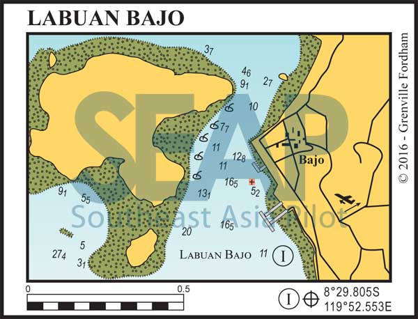
Approaching from the south on NW heading running past the small river on starboard to find a good spot about 250 metres south of the square concrete commercial jetty. Anchor here in 12-14 meters on sand. The northern channel is narrower (but still safe), so more attention is required. There are strong currents running through the channel between town and Bajo Island and when wind and tide oppose it gets interesting.

To describe Labuan Bajo Anchorage as chaos is an understatement, with hundreds of boats of all shapes and sizes accessing and using this area. Unless you have something specific to do in Labuan Bajo it is only a stop-and-go location.
Once at anchor, dinghy in just past the north wall of the commercial pier where a restaurant owner has a private dock you can readily use without charge. The Harbour Master’s office and town amenities are a short walk. Since late 2018 there is cement floating pontoon and public small craft jetty just south of the water front market. As with anything in Labuan Bajo, take great caution as all level of small craft are zipping in and around these areas.
Labuan Bajo is the closest populated settlement to Komodo with flight connections to other Indonesian destinations. Many tour operators and local charter boats use it as the pickup point for their Komodo and Rinca Island excursions.
This once-quaint waterfront town has fast developed into the next hyper-growth tourist area east of Bali and the Gilis, with facilities for cruising yachts. Unfortunately marine operations support has not kept up with this growth. Nevertheless, on a relatively primitive scale anything and everything a cruising yacht needs is available – with access to small repairs, fuel, water and local provisions. Anything with any level of sophistication, including first-world provisions, has to be flown in from from Bali.
Labaun Bajo has a cosmopolitan range and quality of restaurants and eating-houses. It is a livewire of activity for diving and snorkelling tours and has some interesting overland excursions to unique villages in the mountains behind the town.
Click to view Indonesia photo gallery.
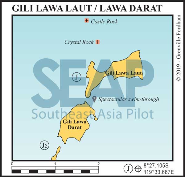
If coming from the east you need to round the northern tip Gili Lawa Laut itself, keeping a medium distance off but not wide enough to bring hitting Crystal Rock on your port side into play.
Castle Rock is further to the north of Crystal in between Crystal Rock and the small rocky island of Tokotoko.
Crystal Rock 8° 26.384S, 119° 34.010E
Castle Rock 8° 25.871S, 119° 33.738E
Once through the passage between Gili Lawa Laut and Crystal rock, on a southern course, yachts can find comfortable 30-40 metre anchorages with two options.


This anchorage is directly to the west of the middle of island Gili Lawa Laut. It’s a wonderfully scenic location and good to use if there is no strong E or NE swell.
It has closer access to the beautiful bay on the north of Gili Lawa Laut and the two superb dive sites of Castle & Crystal Rocks
This anchorage is better suited if there is some E or NE swell entering the bay. It ‘s located as you go past the passage between Gili Lawa Darat and northern tip of Komodo island itself.
Same approaches as anchorage [J], except go further south into the main jaw of the unnamed bay where you can find 20-30 metres in sand to put the anchor
The bay and beach on the north face of the island is highlighted by all year round azure blue water with water visibility often over 40 metres. The snorkelling in this bay is outstanding, with sea turtle and mantas common. Like all beaches in the area, this stunning white sand beach has only high tide access.
An adventure activity whilst in this area is the swim through between Gili Lawa Laut to the North and Gili Lawa Darat. When the tide is running there are often mantas feeding in the gap between these islands.
WARNING: Snorkelling swim-through activity here should always include a crewed support tender close by as currents are fast and unpredictable.
The scuba dives at Castle and Crystal Rocks are amazing signature dives for the area but, again, should be planned only with support tender and great caution due to the fast drift and current flows. Medium level to advanced experienced divers only – unless beginners are supervised by qualified dive guides.


Give plenty of water to the northern tips of Banta Bay for an unobstructed run to the anchorage, which for superyachts is at 40 metres on sand. Shallower draft vessels can poke into a comfortable depth, but best on the 15-metre bank rising to 2 metres on sand at 8°24.961S, 119°16.809E.
Once at anchor the Banta activity menu is extensive. There is a wonderful ridge walk offering unbelievable elevated scenic views of the whole island. The diving and snorkelling over the fringing reef is fabulous and there is a white sand beach on the east coast that is post card quality. There is further exploration and scenic beauty through the wash-throughs and eroded isthmus rock fingers along the headland shorelines.
