Once relatively unknown, compared to neighbouring Bali, Lombok has grown to be a popular tourist spot. Lombok offers comparatively unspoiled islands and beaches, reminiscent of Southeast Asia decades ago. The main focus for cruising yachts is the magical Gili Islands, which we arbitrarily break down into the North Gilis, the South Gilis and the Southwest Gilis.

70 miles from Bali


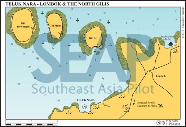
Facing north towards the popular Gili group, and directly south of our Gili Aer anchorage, is Teluk Nara (AKA Teluk Kombal). This busy close-to-shore anchorage on the northwestern coast of Lombok is the jumping-off point for the Gilis and even Bali. Regional tourism has grown exponentially since the first editions of this book.
On entry do not cut either of the north corners because the reef extends further than you’d expect on both. Favour the mid channel and motor right inside to anchor in the southwest corner in 14-22 metres on clay and mud. Teluk Nara is 25-minute drive from Sengiggi, the main tourist beach of Lombok, where there are more restaurants and better supplies than you’ll find on the Gili islands or in local villages. An hour further south is the capital Mataram, with even more extensive markets – and repair shops with a limited understanding of yachts needs.
In 2017 the government moved the Lombok airport from Mataram to Praya on the south of the island, making the journey from Teluk Nara to the airport a two-hour trip.
There are a dozen moorings in the bay, but only a few are available for hire to visiting yachts. There are several small dinghy and shallow draft jetties and floating docs scattered all around the bay for local speedboats, plying mainly out to the Gilis. Each day many college-age backpackers are transferred to the Gili islands creating annoying noise and wake. If you’re looking for peace and serenity this isn’t the spot.
Directly north a few miles are the famous Gilis – Trawangan, Meno and Aer. At quieter Gili Aer, take the south passage to shelter behind the reef about 300 metres off the main jetty. Continue past the moorings (unless one is free) to anchor on the 6-13 metre sand shelf at 8°21.924S, 116°04.933E. This spot gives great access to everything on the island.
To explore, snorkel or dive on neighbouring Gili’s Meno and Trawangan, best to pick up a marine park mooring rather than risk anchoring amongst the coral heads in strong currents. The orange ones are generally for heavier boats, but if in doubt get overboard and personally check the tackle. The Gili locals and dive operators work hard keeping their reef heritage intact. They have started various NGOs responsible for reef protection and restoration in the area. Anchoring on their reefs is closely monitored.
Trawangan has the most accommodation and caters to young people’s parties and even some isolated rave culture nightlife. There are no motorised vehicles on Gili Trawangan, which gives it a certain rustic laid-back charm.
Five miles east of the Gilis, Medana Bay Marina is run by British expat, Peter Cranfield, and his Indonesian wife, Ace. They have created a small serene haven for visiting yachts in Teluk Dalem (Deep Bay) facing north on Lombok’s coast. Located at 8°21.888S, 116°07.766E, it’s a north south entry through the fringing reef from waypoint 8°20.431S, 116°07.683E.
dozen floating docks if you have an advance booking. Medana Bay Marina continues to host the Sail Indonesia Rally from Darwin each year. www.sailindonesia.net
The restaurant ashore has food and drink at reasonable prices. Laundry, water and other provisions can be arranged through the small bungalow hotel adjoining. www.medanabaymarina.com
Click to view Indonesia photo gallery.
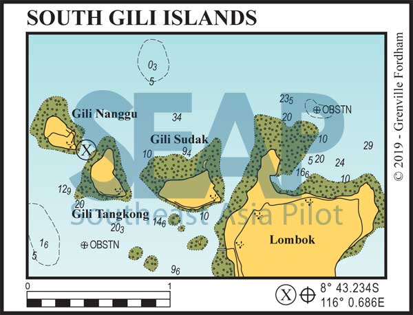
08°43.234S, 116°0.686E
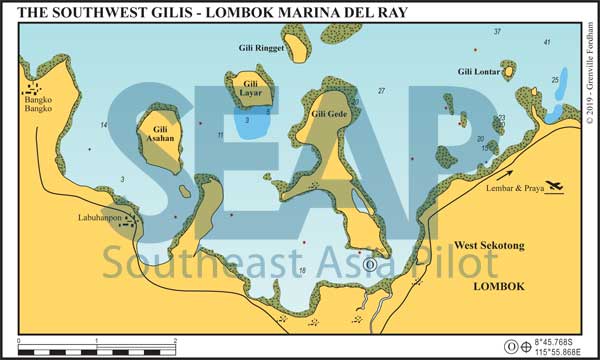
08°45.738S, 115°56.026E
On top of the southwest ‘foot’ of Lombok are a dozen more Gili Islands touted as ‘The Maldives of Indonesia’. These ‘other’ must-see Gilis lie 10 miles west of Lembar, south Lombok’s main town and commercial port. It is this area that now has the closet access to the new international airport at Praya.
This group of islands, that we’re calling the Southwest Gilis, offer plenty of protected anchorages in clear water close to shore. Clustered close to each other and near the coast, they enjoy the added shelter of Lombok’s lower hills. On the south tip of the biggest, Gili Gede (Big Island in Susak – Lombok’s indigenous language) is Marina Del Ray.
The diving and snorkelling are good all around this group, especially off the outer islands and particularly the reef opposite Gili Ringget. Small, sandy Gili Lontar to the east is uninhabited and a great day visit.
Three miles further east, are the South Gilis. There’s good overnight holding in the channel between Gilli Tangknong and Gili Nanggu (8° 43.234S, 116° 0.686E) in 8-12 metres with a small resort on the latter (see ‘X’ on South Gilis chartlet).


40 miles from Bali


The location currently provides a sheltered anchorage in 12 metres on sand directly outside the small dock. The marina company has already laid 20 strong tackle commercial moorings and have a single fixed floating pontoon at which 20 boats can moor stern-to.
Some permanent local yachts are already occupying this new facility and it has very good transient vessel occupations. Ashore are the Marina Del Ray Yacht Club Bar and a small resort.
Lombok’s main commercial harbour Lembar Port is eight miles to the east. Here is direct access to Lombok International airport, ferries to Padang Pai Bali and overland transport into Mataram or Sengigi.
