>   Thailand   >   Koh Lanta to Tarutao

Koh Butang Group

Koh Rawi, the Butang Island Group
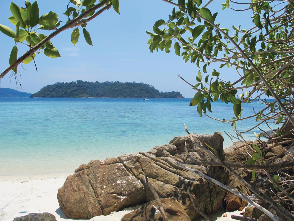
Anchorage ‘F’ Koh Rawi, looking southeast towards Koh Barat | Photo by Suphaporn Fordham

The Butangs is a group of islands approximately 27 miles to the northwest of Langkawi and 95 miles southeast of Phuket in the Andaman Sea.

There are 15 or so granite islands including Koh Lipe, Koh Adang, Koh Rawi, Koh Butang, Koh Sawang, Koh Kata, Koh Bulu and Koh Bitsi. They are cloaked with lush rainforest and fringed with coral reef and white sand beaches. The islands provide exceptionally good snorkelling and diving on well-preserved coral. They are within the Tarutao National Marine Park, which consists of a total of 51 islands.

[read more]

The smaller southern island Koh Lipe is the most important and now hosts numerous resorts. With groundwater available year-round it is the largest permanent settlement. The native community is a mix of Chao Lay, Muslim and Buddhist and the population has grown rapidly since regular ferry services were established from Satun, Pak Bara and Langkawi. The small town has ATM machines but no bank branch.

The Chao Lay or Urak Lawoi, more commonly known as sea gypsies, used to lead a nomadic lifestyle but the community on Koh Lipe has been settled for decades.

These islands provide many quiet secluded anchorages, most with mandatory National Parks moorings. The water is deep, with the sea bed rising rapidly to 20 metres. Anchoring in areas without moorings can only be found on sandy shelves between 10 and 20 metres close to the fringing reef and rocks on the west coast of Adang, the gap between Rawi and Butang and around Koh Lipe. Closer in other places the reef rises too rapidly from deep water to be safe.

The National Park authorities are strict collecting fees and ruthless with vessels found anchoring on top of the reefs. Always pick up a mooring if one is around.

Daily ferries service Koh Adang, Koh Rawi and Koh Lipe, which offer basic accommodation. Koh Lipe houses a full CIQ facility with customs and immigration for the hordes coming from Langkawi, Malaysia, but there’s still no Harbour Department.

[/read]

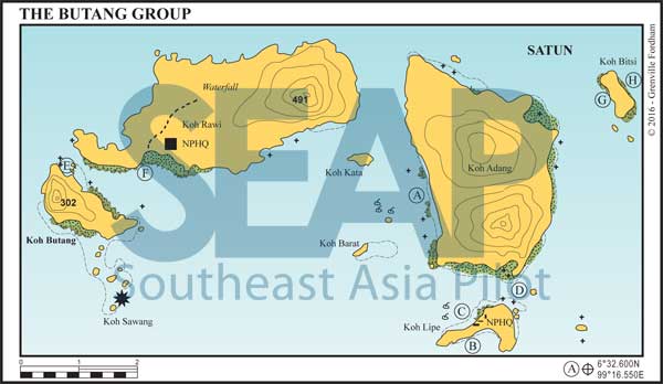
Butang Island Group chart
  • A

KOH ADANG WEST

56 miles from Koh Lanta Lighthouse

KOH ADANG WEST. 6°32.600N, 99°16.550E

There are now upwards of 15 national park moorings all along the west coast of Koh Adang. All are laid in outside the reefs in deeper than 12 metres areas. Anchoring is also allowable in 10 metres on the sandy shelf off the small village toward the southern end of the island.

In strong northeast winds this coast is the best anchorage in the entire Butang Group. The numerous beaches and reefs here mean it’s still possible to find a quiet spot away from the many longtails and speedboats. A warning for social media addicts; no cell coverage on this coast.

Click to view Thailand photo gallery.

  • B

KOH LIPE SOUTH

62 miles from Koh Lanta Lighthouse

KOH LIPE SOUTH. 6°29.060N, 99°18.126E

Anchor in 20-25metres (certainly no less than 15) off the fast-rising fringe reef on a sandy bottom. Pattaya Beach ashore has a number of resort and bungalow developments.

The best beach dinghy landing areas are in the east of the bay, where there is a small sandy channel through the coral, and alongside the floating jetty at the entrance to ‘Walking Street’. There is no access, though, at low tide.

Approaching from the west, there are some exposed rocks at low tide. Avoid anchoring too close to ferry buoys, which have now spread westwards, leaving increasingly less room for yachts.

Unfortunately, this bay has been taken hostage by large offshore rafts and jetties for the fast ferries and large speedboats that now bring hordes of tourists to the island.

Click to view Thailand photo gallery.

  • C
  • D

KOH LIPE NORTH

59 miles from Koh Lanta Lighthouse

KOH LIPE NORTH (C). 6°29.559N, 99°17.838E

(C) is now the preferred anchorage for Koh Lipe. Anchor in 7-10 metres on sand. The coral is easy to spot, as the water is very clear. With care the beaches are accessible at all states of tide but at low certainly head for the spot next to the beach bar where the longtails are parked. A short rocky path leads to a motorbike and sidecar taxis pick up point to town (or it’s a 10 minute easy walk).

[read more]

The island has paved road systems and motorbikes and tuk tuks race around at speed ferrying tourists about. Restaurants are plentiful and cater for all tastes and budgets. There are several supermarkets and 7-11s, two international clinics and three Phuket-style beach clubs with swimming pools.

Despite its accelerated development from a sleepy fishing village, Koh Lipe still has its own south Thailand charm and is the main base for yachts visiting the Butangs; cell coverage works great at the anchorages here.

Anchorage (D) 6°29.725N, 99° 18.765E, just west of Hin Takon Dukang, is better in the southwest season in 8-10 metres. Anchorage is also available on the east coast off Sunrise Beach between the two islands to the east of Koh Lipe in 15-20 metres.

To the north, across the channel, on the southern tip of Koh Adang is another gypsy village with a jetty in a sandy lagoon, which can be accessed by dinghy.

It’s well worth dinghying ashore to the NPHQ jetty on the south side of Adang and climbing at least some of the mountain to get an aerial view down onto Koh Lipe and out across to Langkawi and Tarutao.

[/read]

Click to view Thailand photo gallery.

  • E

KOH BUTANG NORTH

56 miles from Koh Lanta Lighthouse

KOH BUTANG NORTH. 6°32.409N, 99°9.770E

Anchor west off the small islands in 8-12 metres with enough swinging room to avoid the fringing reef. This area is ideal for snorkelling and fishing; there are wild monkeys on the beach. Anchorage and moorings can also be found in 20 metres east of the islets, if the northeast ground swell wraps around the south of Koh Rawi.

Day anchorage and moorings can also be found around the islets of Koh Palai and Koh Sawang to the south of Koh Butang. This is generally considered the best snorkelling, diving and fishing in the group. The bottom rises sharply from depths of more than 25 metres around these southern islands and any day anchorage should be approached with caution.

Click to view Thailand photo gallery.

  • F

KOH RAWI SOUTHWEST

57 miles from Koh Lanta Lighthouse

KOH RAWI SOUTHWEST. 6°32.511N, 99°11.408E

Pick up a mooring or anchor in 5-10 metres on the sandy shelf east of the protruding reef bank opposite the beach. Keep well clear of the extending reef to the east on approach. The current is strong in this passage and care should be taken when snorkelling.

The National Park HQ is located to the east. Anchorage can be found near the HQ in 5-8 metres or further off in deeper water. Ashore there’s a freshwater creek and a 45-minute jungle trail leading to a year-round waterfall.

Near the beach is a black pipe where jerry cans can be filled with fresh water. Day anchorage and snorkelling can also be found in the middle of the bay on the other side of the isthmus in 10-14 metres.

Click to view Thailand photo gallery.

  • G
  • H

KOH BITSI WEST AND EAST

57 miles from Koh Lanta Lighthouse

KOH BITSI (G) 6°33.872N, 99°20.533E
(H) 6°51.131N, 99°20.996E

Northeast of Koh Adang is a small island with good holding close to shore on either the east or west coast depending on the season and ground swell. Good snorkelling and diving.

Click to view Thailand photo gallery.
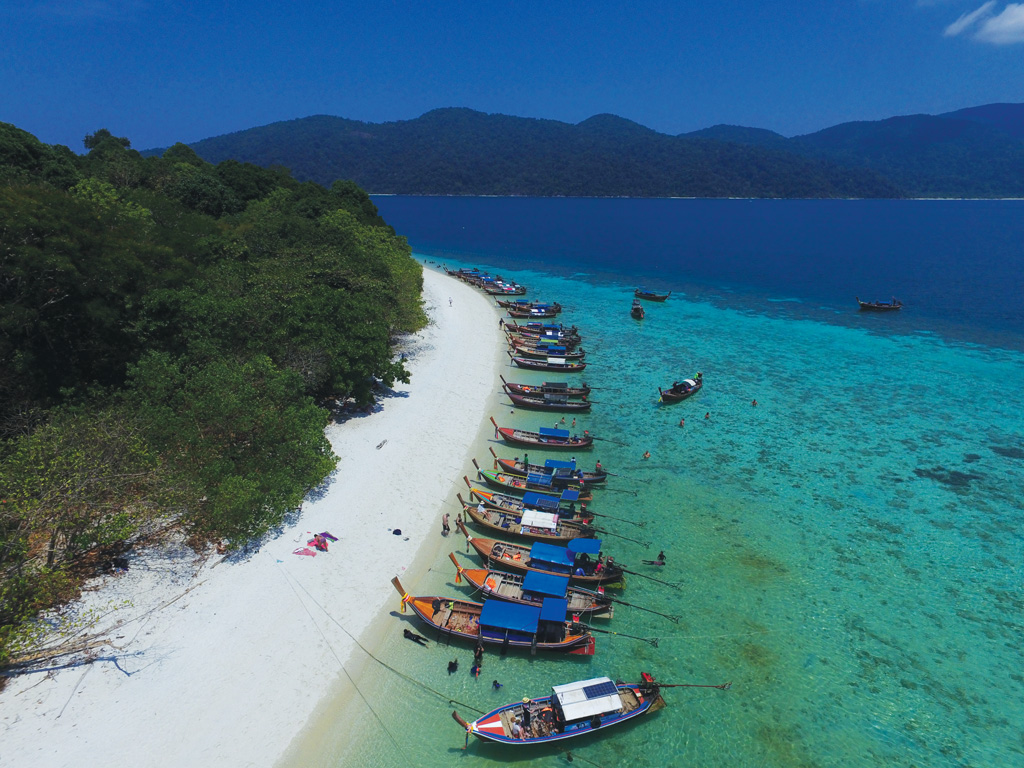
Southeastern end of Koh Rawi
Day trippers on the southeastern end of Koh Rawi | Photo by Photo by Grenville Fordham

See also:

  Go to top

While every effort has been made to ensure that the information contained in this book is accurate, the charts of anchorages are based on personal experience and satellite imagery and are intended as a guide only. They should not be used for navigation. Please refer to Official Hydrographic Charts of the respective countries.

Copyright.
The copyright holders of all content, in print and digital editions, are: Published book © Phuket Publicity Services Ltd. Part. / Texts © Bill O’Leary, Andy Dowden & Grenville Fordham / Design, layout & charts © Grenville Fordham / Photography: © as indicated in photo credits. All rights reserved
No part of this publication may be reproduced, stored, or transmitted in any form or by any means - graphic, electronic or mechanical, including photocopying, recording or otherwise – without the express permission of the publisher, Phuket Publicity Services Limited Partnership, and the other copyright owners.

Phuket Publicity Services Partnership, Ltd.,
Phuket Publicity Services Partnership, Ltd.,19/87 Moo 7,T.Srisunthorn, A. Talang, Phuket 83110 Thailand
Privacy policy