>   Thailand   >   Koh Lanta to Tarutao

Koh Ngai, Koh Muk & Koh Kradan

Anchorage ‘C’ on Koh Muk
Anchorage ‘C’ on Koh Muk – The shoreline is honeycombed with crevices and caves | Photo by Grenville Fordham

These three islands are the northernmost in the Hat Chao Mai National Park and are the most visited by tour boats. Quite different from each other in geology, they all have some bungalow development and interesting features.

The area just south was part of Malaya until 1909 and its ancient Muslim culture migrated north, with mosques still dominating these remote fishing villages.

[read more]

In addition to the pristine beaches and fertile scenery of the islands, Tham Morakot (Emerald Cave) at Koh Muk is the must-see highlight of the region.

Perhaps the best way to explore the area is to rent a longtail boat for the day, which can be arranged through the shoreside bungalows. Prices range from 500 baht per person.

Trang town, the provincial capital with its airport, is 30 kilometres inland and there are ferry piers at Pak Meng and Had Yao giving main road access.

The Anantara Sii Khao is located on the mainland at Pak Meng Beach and is heralding this area as a destination for more exclusive travellers.

[/read]

Koh Ngai, Koh Muk & Koh Kradan chart
  • A

KOH NGAI EAST

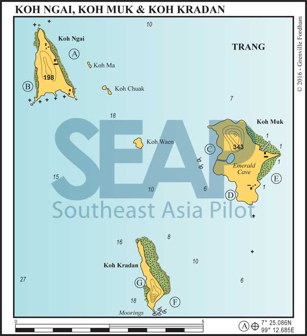
8 miles from Koh Lanta Lighthouse

KOH NGAI EAST. 7°25.086N, 99°12.685E

Anchor anywhere off this coast in 6-8 metres. On the southeast corner a small jetty serves bungalows and a restaurant where limited supplies are available.

The east coast is a long white sand beach fringed with coral. At the north end, the Koh Ngai Villa is the most upscale in the area, with spacious fan bungalows and a restaurant with stunning panoramic views. This coast has become more built up in recent years, but in the southwest (low) season, when it’s more protected as an anchorage, most of the restaurants are closed down.

[read more]

The resort pier on the southeast tip is a handy place to fill your tanks, but it’s advisable to approach at high tide or survey and assess your approach with the dinghy in advance, as there are a few shallow rocks close in.

The large double bay on the south side of Koh Ngai has a buoyed-off coral reef area and several heavy mooring buoys for yachts. It’s a good daytime snorkelling stop with a few beach bars and restaurants ashore. For the adventurous, there’s a short 30-minute shady jungle walk on a path that leads back over to the east coast.

There’s an old Sea Gypsy fishing village on the northeast corner of the island. Koh Ma and Koh Chuak, both large rocky outcrops, offer great possibilities for exploring by dinghy or canoe.

[/read]

Click to view Thailand photo gallery.

  • B

KOH NGAI WEST

6 miles from Koh Lanta Lighthouse

KOH NGAI WEST. 7°24.315N, 99°11.649E

Anchor in 8-10 metres off any of the three beaches with small resorts ashore on the west coast. These anchorages offer excellent protection in the northeast monsoon.

Click to view Thailand photo gallery.

  • C

KOH MUK WEST (THAM MOROKOT)

13 miles from Koh Lanta Lighthouse

KOH MUK WEST. 7°22.128N, 99°16.963E

Also known as Sabay Bay, this anchorage is our pick of the group. Anchor in the northeast monsoon only in 6-8 metres between the two towering cliffs and off the very small beach. The shoreline north and south is honeycombed with crevices and caves, making for excellent dinghy exploring. The beach leads to a small freshwater creek. There is a rough path that leads up over the hill to the main village of Koh Mak.

A few hundred metres south of the anchorage is the entrance to Tham Morakot − the ‘Emerald Cave’− easily recognisable by the mooring buoys with ropes leading into the entrance of the cave.

[read more]

The entrance is an 80-metre pitch-dark passageway leading to a completely enclosed circular, cathedral-like ‘hong’, with a diameter of 60 metres. A buoyed line makes it easy for all comers to drag themselves through the dark tunnel and into the hong. Do not try to negotiate the passage without a reliable waterproof torch. It’s terrifying enough. Kayaks and dinghies are not permitted into the cave; it’s for swimmers only. The park rangers will visit your boat to collect the 400 baht per person park fee.

The walls inside the internal hong are draped in lush foliage above a tiny patch of grey silica sand beach and the ethereal glow makes it seem as if you were encased inside an emerald, looking out.

Never mind the untidy lines, moorings and jostling day boats at the entrance. This experience will remain etched in your memory for the rest of your lifetime. Awesome!

[/read]

Click to view Thailand photo gallery.

Inside the Emerald Cave on Koh Muk
Inside the Emerald Cave before the ban on kayaks & dinghies (we paddled in and out!) | Photo by Grenville Fordham
  • D

KOH MUK SOUTH

14 miles from Koh Lanta Lighthouse

KOH MUK SOUTH. 7°21.531N, 99°17.540E

This secluded anchorage in 6 metres offers good holding on a muddy bottom. Sometimes there is also a buoy available.

Facing southwest, the bay has an all-tide beach and makes an ideal overnight haven in the northeast monsoon season. Perched high on, and jutting out over, the rocks at the southern end of the bay is a no-name, family-run, restaurant with good food and a warm welcome for yachties.

[read more]

Lift your dinghy well up onto the dry sand or tie it to the swim line well away from the shore as there is often a heavy dinghy-flipping, shore-dumping wave from passing ferries or the occasional cargo ship wake.

Ashore there’s an excellent cliff top bar at the southern end of the bay where you can get a drone-like aerial shot of your yacht and the sunset. Several resorts on the beach welcome yachties and there’s a small bakery and mini market close to the main road.

The walk through to the main town on the east side of the island is a pleasant, flat, shady 20-minute walk or you can take a motorbike and sidecar taxi to the other coast. The standard Thai fishing town has good local supermarkets and supplies.

[/read]

Click to view Thailand photo gallery.

  • E

HAT SAI YAO & EAST COAST KOH MUK

15 miles from Koh Lanta Lighthouse

HAT SAI YAO. 7°22.105N, 99°18.648E

Anchorage can be found in the shallow southeast facing bay in 3-5 metres on a sandy bottom. Ashore are Sawadee Resort and Charlie’s Bungalows on the 800-metre-long, jungle-backed beach. The Sivalai Resort occupies the sand spit running east to the north of the anchorage.

Shallow anchorage is also possible east and north of the sandy headland halfway up the east coast. A long jetty is situated at Hua Laem Muslim village and Koh Muk Resort is to the north.

Click to view Thailand photo gallery.

  • F

KOH KRADAN S.E. BAY

14 miles from Koh Lanta Lighthouse

KOH KRADAN SOUTHEAST BAY. 7°18.168N, 99°15.527E

Look for anchorage off the small southeast-facing bay with a small resort ashore. The bay remains deep until close in, and vessels can pick up a mooring or anchor in no less than 10 metres. At the south end of the beach is a small National Park Head Quarters with exceptional snorkelling offshore. There are several small resorts ashore and a trail leading through to the west and east coasts.

This makes a nice day anchorage although, depending on the prevailing season, better overnight holding can be found on the east or west coasts. The Anantara Si Kao Beach Club and a small bungalow resort welcome visitors. Anchorage is available in no less than 12 metres anywhere along the east coast, taking care to approach the visible fringing reef very slowly and preferably perpendicular to the beach.

Click to view Thailand photo gallery.

  • G

KOH KRADAN WEST BAY

12 miles from Koh Lanta Lighthouse

KOH KRADAN WEST BAY. 7°18.487N, 99°15.049E

Reasonably sheltered in the northeast season, this anchorage lies in 10-12 metres on a muddy bottom. This stunning beach is palm-fringed and a track cuts through the island to the eastern side where there are eight restaurants.

Click to view Thailand photo gallery.

See also:

  Go to top

While every effort has been made to ensure that the information contained in this book is accurate, the charts of anchorages are based on personal experience and satellite imagery and are intended as a guide only. They should not be used for navigation. Please refer to Official Hydrographic Charts of the respective countries.

Copyright.
The copyright holders of all content, in print and digital editions, are: Published book © Phuket Publicity Services Ltd. Part. / Texts © Bill O’Leary, Andy Dowden & Grenville Fordham / Design, layout & charts © Grenville Fordham / Photography: © as indicated in photo credits. All rights reserved
No part of this publication may be reproduced, stored, or transmitted in any form or by any means - graphic, electronic or mechanical, including photocopying, recording or otherwise – without the express permission of the publisher, Phuket Publicity Services Limited Partnership, and the other copyright owners.

Phuket Publicity Services Partnership, Ltd.,
Phuket Publicity Services Partnership, Ltd.,19/87 Moo 7,T.Srisunthorn, A. Talang, Phuket 83110 Thailand
Privacy policy