Malacca Marina anchorage and reclamation looking north | Photo by Bill OLeary
Due to its strategic location on the strait that bears its name, Malacca was a rich trading port long before it became colonised by a succession of invaders. The Portuguese, the Dutch and the British all held sway in this UNESCO world heritage city over the past centuries.
Today the wealth and trade are a thing of the past but the legacy architecture and history makes it a key player in Malaysia’s tourism industry.
South of the river mouth, the massive offshore Melaka Gateway reclamation development project is well underway. The entire complex plans for a cruise ship terminal, marina, boardwalk, retail, real estate and hotel components all due for completion in several phases up to 2027.
The superyacht marina is planned for inside the reclamation between the islands and eventually will cater for up to 350 berths. The Malacca Gateway project markets itself as a future superyacht haven and will house a travel lift, hardstand and all the auxiliary marine service industries.
A few hundred metres north of the river mouth is another massive private residential reclamation project running three-quarters of a mile out to sea. Both projects provide plenty of shelter tucked between them in all but strong westerly winds.
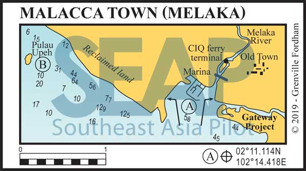
There is a shoddily built 40-berth government-sponsored marina just outside the north bank entrance of the Melaka River. It has suffered terrible siltation issues and internal wave refraction in the past but at the time of writing it was open again with a recently dredged depth of 3 metres throughout.
It has 8 berths with plans for another 40 and is manned by Marine Department officers who accompany foreign yacht crews to the CIQ ferry terminal nearby for check in and out procedures. Officers assured us that the marina is again open for business and will be fully fitted out for foreign yachts by end of 2019.
They report the recent land reclamations north and south have provided much needed shelter, dampening the wave refraction and the siltation inside. However, for deeper draft vessels or first time visitors we still recommend anchorage outside the western revetment wall and take your dinghy into the internal dock.
>>> Click herefor a complete list of anchorages in Southeast Asia Pilot.
A
MALACCA
100 miles from Singapore
MALACCA. 2°11.114N, 102°14.418E
Until the first phases of the Gateway Marina project open in late 2020 the safest place to anchor is still just outside the west wall of the government marina on mud in 4-6 metres.
The shoddily constructed seawall used to offer varied wave protection but recent north and south land reclamations are reported to have created a much calmer internal area. At the time of writing there was a dredged 2.5-3 metres inside and at the entrance.
Take your tender to the main dock inside the marina and register with the Marine Department officers in the building ashore there. The officers will know the current depths in the basin and arrange all your needs.
The Malacca river entrance bridge height is around 10 metres, restricting all but the smallest sailing boats.Further up and inside the river on the left bank island is the CIQ ferry terminal with daily ferries to Bengkalis, Dumai and Pekanbaru in Sumatra Indonesia.
Immigration is available at the CIQ terminal and the officers will arrange your transport. You can request permission to ply the historic river with your own dinghy but it’s better to simply join one of the many-scheduled Malacca River cruise boats.
Opposite the CIQ on the south bank, the Flora de la Mar maritime museum is well worth a visit, as are the historic sites, forts and churches. Take one of the art-deco funky pink bicycle rickshaws to enjoy the best Malacca town has on offer.
Jonker Street (walking street) is famous and well worth a stroll around sunset or after dark, and the local Mamak and Chinese street food are legendary. Proper attire is recommended.
It’s fun but nothing like the chaos of Phuket or Pattaya’s walking streets.
Two miles north of the Malacca River entrance, only a half-mile offshore the new reclamation, is the tiny island of Pulau Upeh. Early Portuguese sailors also knew it as Des Pedra or ‘place of stone’. Anchor 50 metres east of the Tenaga Nasional jetty on sand in 2-4 metres.
Ashore the small resort welcomes yachts and offers a pool, restaurant and water sports. There’s an ancient freshwater well and several relics from WWII scattered around the island. Pulau Upeh is famous as the local WWF sanctuary for nesting hawksbills, one of the rare species of sea turtles in the region. Hundreds come on shore at night to make their nests on the main beach.
Directly opposite only a few hundred metres away on the reclamation site are fast-appearing new condo developments and the new 4-lane coastal road.
Note that this website may not reflect the most recent updates to the printed book and the eBook. While every effort has been made to ensure that the information contained in this book is accurate, the charts of anchorages are based on personal experience and satellite imagery and are intended as a guide only. They should not be used for navigation. Please refer to Official Hydrographic Charts of the respective countries.