SEAP Southeast Asia Pilot-1

Port Klang

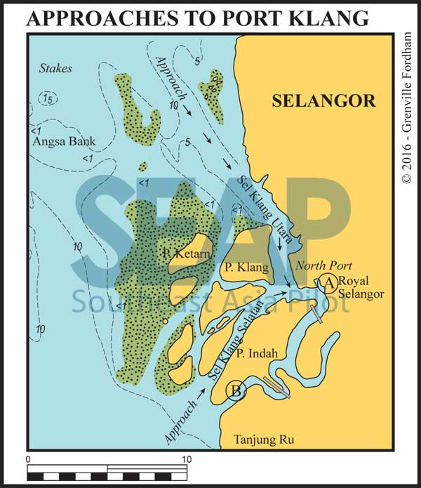
Approaches to Port Klang chart

Port Klang is tucked into the shelter created by Pulau Klang with main cargo docks north of the river entrance. A busy port, it’s the main cargo terminal for Kuala Lumpur 40 miles inland.
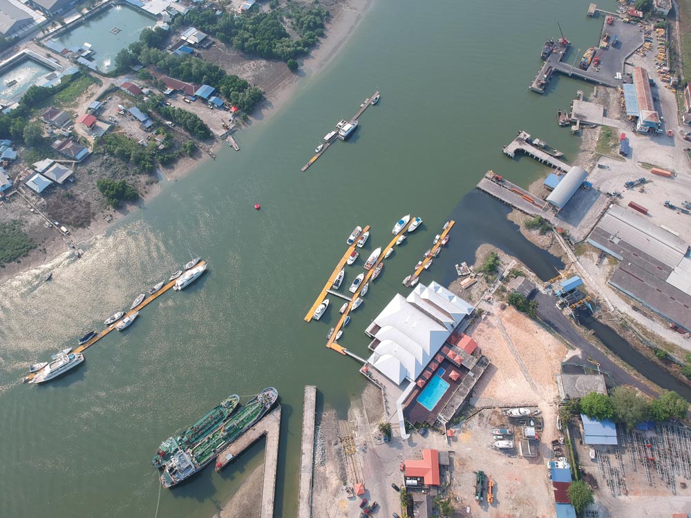
Royal Selangor Yacht Club at Port Klang
  • A

ROYAL SELANGOR YACHT CLUB

180 miles from Singapore

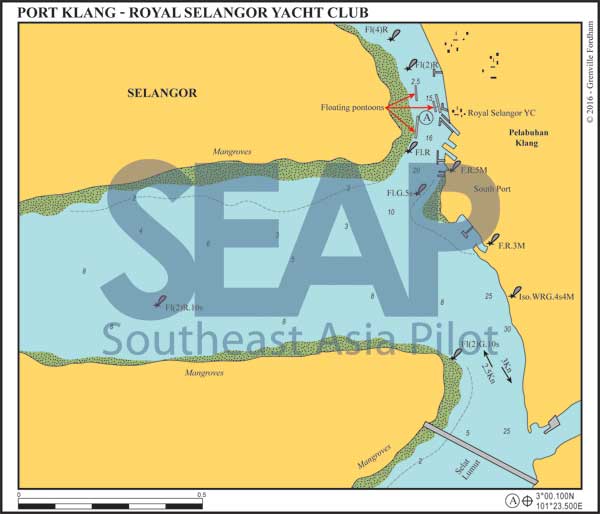
PORT KLANG – ROYAL SELANGOR YACHT CLUB 3°00.314N, 101°23.374E

Approach the Royal Selangor Yacht Club from either the southern Selang Klang Selatran or the northern Selang Klang Utara channels. Both are deep and well buoyed for ships. From the west at Cardinal buoy “TAIL” at 3°0.406N, 101°21.219E, steer port to a Red lateral buoy “S.AGAS” at 2°59.759N, 101°22.536E then head for the Red lateral buoy “SK1” at 3°0.179N, 101°23.302E.

[read more]

There are some 30 club members’ berths attached to the clubhouse, with longitudinal space for half dozen visitors’ boats on the detached pontoons both sides of the river.

The club is the oldest in Malaysia with a rich history. It is the host club to the Raja Muda Selangor International Regatta from Port Klang to Langkawi, held yearly in late November.

Only the club member berths have water and electricity. Refuelling and watering is difficult, but can be arranged with advance notice on the club pontoons.

Currents of 1-3 knots run in the river around mid tide. It’s best to arrive in daylight close to slack water for safer mooring. Contact on VHF Ch. 72 for berthing advice before tying up. Kuala Lumpur is 40 minutes by taxi.

[/read]

Click to view Malaysia photo gallery.

Royal Selangor Yacht Club at Port Klang
Port Klang’s Royal Selangor Yacht Club | Photo by Bill O’Leary
  • B

MARINA PULAU INDAH

175 miles from Singapore

MARINA PULAU INDAH. 2°54.504N, 101°18.860E

This marina has 120 berths in the calm waterway behind Pulau Indah. It was one of many marinas built by the government to promote recreational yachting. Long abandoned since inception, it has recently become home to the Peninsular Sailing Club Selangor.

Built and managed by the Marine Department, security guards allow visiting yachts to berth inside free of charge for a few days, but will jot down all your details.

[read more]

The marina can only be accessed from the south due to the two bridges connecting Pulau Indah to the mainland on the north. Approaching best divert northeast at the first port and starboard markers into the river tucked behind Pulau Indah.

This is remote but practical for emergency pit stops up the Straits or to grab supplies from Kuala Lumpur without enduring the slog up into Port Klang. Good safe holding in 6 metres on mud can be found in the calm anywhere in the channel south of the marina.

[/read]

Click to view Malaysia photo gallery.

See also:

  Go to top

While every effort has been made to ensure that the information contained in this book is accurate, the charts of anchorages are based on personal experience and satellite imagery and are intended as a guide only. They should not be used for navigation. Please refer to Official Hydrographic Charts of the respective countries.

Copyright.
The copyright holders of all content, in print and digital editions, are: Published book © Phuket Publicity Services Ltd. Part. / Texts © Bill O’Leary, Andy Dowden & Grenville Fordham / Design, layout & charts © Grenville Fordham / Photography: © as indicated in photo credits. All rights reserved
No part of this publication may be reproduced, stored, or transmitted in any form or by any means - graphic, electronic or mechanical, including photocopying, recording or otherwise – without the express permission of the publisher, Phuket Publicity Services Limited Partnership, and the other copyright owners.

Phuket Publicity Services Partnership, Ltd.,
Phuket Publicity Services Partnership, Ltd.,19/87 Moo 7,T.Srisunthorn, A. Talang, Phuket 83110 Thailand
Privacy policy